|
|
|
Lighthouses of The Great Lakes Region
(Includes: Lake Champlain & Saint Lawrence Seaway)
[  | A | B | C | MAP | | A | B | C | MAP |  ] ]
A. Lake Champlain & Saint Lawrence Seaway:
[ VT | NY ]
Vermont (4)
Lake Champlain
1. Burlington Breakwater Lights (North, Middle, South)
- Location: Burlington, Chittenden County, VT
- Coordinates: (North) 44°28'42.0"N 73°13'40.0"W (44.4783, -73.2278)
- Status: Active.
- History: A series of modern lights on skeletal towers marking the ends and middle of the Burlington breakwater. They replaced earlier, more traditional lighthouse structures.
- Viewing Information: The breakwater is not accessible. The lights can be viewed well from the Burlington waterfront and Waterfront Park.
2. Isle La Motte Lighthouse
- Location: Isle La Motte, Grand Isle County, VT
- Coordinates: 44°54'25.0"N 73°19'49.0"W (44.9069, -73.3303)
- Status: Deactivated. Privately owned.
- History: An 1881 cast-iron tower that guided vessels on the northern part of Lake Champlain. The light was deactivated in 1933 and is now part of a private summer home.
- Viewing Information: Private property and not accessible. It can be viewed distantly from the water.
3. Juniper Island Light
- Location: Juniper Island, Burlington, Chittenden County, VT
- Coordinates: 44°27'43.0"N 73°16'36.0"W (44.4619, -73.2767)
- Status: Deactivated. In ruins.
- History: The first lighthouse on Lake Champlain, this 1826 brick tower was replaced by a skeletal tower in 1846. It was deactivated in 1954. The abandoned tower is now a crumbling ruin.
- Viewing Information: The island is private property. The ruins can only be viewed by boat.
4. Windmill Point Light
- Location: Alburgh, Grand Isle County, VT
- Coordinates: 44°59'11.0"N 73°18'25.0"W (44.9864, -73.3069)
- Status: Deactivated. Privately owned.
- History: A stone windmill was built here in the 1830s. A light was placed in one of its windows in 1858, making it a lighthouse. It was replaced by a steel tower in 1931. The original stone windmill tower still stands.
- Viewing Information: The tower is on the grounds of a private residence and is not accessible, but it can be seen from the road.
[ Back to Top  ] ]
New York (38+34=72)
Lake Champlain
(Northeastern New York)
39. Barber's Point Light
- Location: Westport, Essex County, New York; located on Lake Champlain
- Coordinates: 44.1543°N 73.4045°W
- Status: Inactive, deactivated in 1935
- Built in 1872 as a 36 foot tall limestone structure and is part of an historic district, known as the Camp Dudley Road Historic District.
- Viewing Informaion: The lighthouse can be viewed from the road, however, it is now part of a private residence.
40. Bluff Point Light
- Location: Valcour Island, Clinton County, NY
- Coordinates: 44°37'52.0"N 73°25'39.0"W (44.6311, -73.4275)
- Status: Active (Private Aid).
- History: An 1874 stone lighthouse on Valcour Island, site of a key Revolutionary War naval battle. Deactivated in 1930, the lighthouse fell into disrepair but was restored by the Clinton County Historical Association and was relit in 2004.
- Viewing Information: The island is a state park accessible by private boat. The lighthouse grounds are open, and the tower is open for tours on Sunday afternoons in the summer.
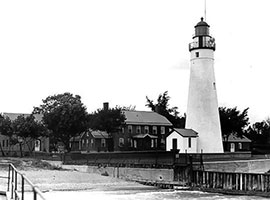
41. Cumberland Head Light
- Location: Plattsburgh, Clinton County, NY
- Coordinates: 44°43'26.0"N 73°24'40.0"W (44.7239, -73.4111)
- Status: Deactivated. Privately owned.
- History: The 1868 stone lighthouse replaced an 1838 original. It was deactivated in 1934 and is now part of a private residence.
- Viewing Information: Private property. It can be seen well from the Grand Isle-Plattsburgh Ferry.
42. Crown Point Light (Champlain Memorial)
- Location: Crown Point State Historic Site, Essex County, NY
- Coordinates: 44°01'48.0"N 73°25'08.0"W (44.0300, -73.4189)
- Status: Deactivated.
- History: The original 1858 lighthouse was heavily modified in 1912 to serve as a memorial to Samuel de Champlain, with a bust by Auguste Rodin. The light was deactivated in 1926.
- Viewing Information: The memorial is a main feature of the Crown Point State Historic Site and is fully accessible to visitors.
43. Point Au Roche Light
- Location: Beekmantown, Clinton County, NY
- Coordinates: 44°46'37.0"N 73°25'40.0"W (44.7769, -73.4278)
- Status: Deactivated. Privately owned.
- History: An 1858 lighthouse that was deactivated around 1900. It is now a private residence.
- Viewing Information: Private property and not easily viewed.
44. Split Rock Lighthouse
- Location: Essex, Essex County, NY
- Coordinates: 44°16'18.0"N 73°22'53.0"W (44.2717, -73.3814)
- Status: Deactivated. Privately owned.
- History: The current 1867 stone lighthouse replaced an 1838 original. It was deactivated in 1928 and is now a private summer home.
- Viewing Information: Private property. It can only be viewed by boat.
[ Back to Top ]
St. Lawrence Seaway
(North Shore of New York)
45. Crossover Island Light
- Location: St. Lawrence River, Hammond, St. Lawrence County, NY
- Coordinates: 44°29'07.0"N 75°45'48.0"W (44.4853, -75.7633)
- Status: Deactivated. In ruins.
- History: The 1882 brick keeper's house with an integrated light tower replaced an earlier 1848 stone lighthouse. It marked a shoal in a narrow section of the river. The station was deactivated in 1941 and abandoned. The structure is now a crumbling ruin.
- Viewing Information: Located on a private island. The ruins can only be viewed by boat on the St. Lawrence River.45. North Brother Island Light
- Location: St. Lawrence River, near De Peyster, NY
- Coordinates: 44°32'42.0"N 75°41'54.0"W (44.5450, -75.6983)
- Status: Deactivated. Privately owned.
- History: An 1870 cottage-style lighthouse that was deactivated in 1961. It is now a private residence.
- Viewing Information: Located on a private island and is best viewed by boat.
46. Ogdensburg Harbor Light
- Location: Ogdensburg, St. Lawrence County, NY
- Coordinates: 44°42'12.2"N 75°30'01.9"W (44.7034, -75.5005)
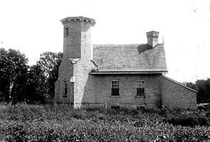
- Status: Active.
- History: The current 65-foot stone and brick tower was built in 1870, replacing an 1834 original. It marks the confluence of the Oswegatchie River and the St. Lawrence River. The light was deactivated for a time but was restored and relit in 2011.
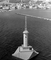
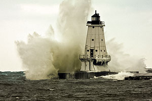
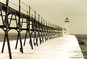
- Viewing Information: Located at the end of a pier at Lighthouse Point in Ogdensburg. The grounds are accessible, and visitors can walk the pier for a close view.
47. Rock Island Lighthouse
- Location: Rock Island, Thousand Islands, Jefferson County, NY
- Coordinates: 44°17'10.2"N 75°59'43.4"W (44.2862, -75.9954)
- Status: Deactivated. State Historic Site.
- History: An 1882 brick lighthouse with the tower attached to the keeper's dwelling. It replaced an 1847 lighthouse and guided ships through the American Narrows of the St. Lawrence River. The station has been fully restored.
- Viewing Information: Located in Rock Island Lighthouse State Park, accessible by private boat or tour boats from Clayton. The lighthouse and keeper's house are open as a museum.
48. Sister Island Lighthouse
- Location: St. Lawrence River, near Alexandria Bay, Jefferson County, NY
- Coordinates: 44°23'24.0"N 75°52'18.0"W (44.3900, -75.8717)
- Status: Deactivated. Privately owned.
- History: An 1870 keeper's house with an integral light tower. The light was deactivated in 1950. The historic structure still stands as a private residence.
- Viewing Information: Located on a private island and is not open to the public. It can be viewed on Thousand Islands boat tours.
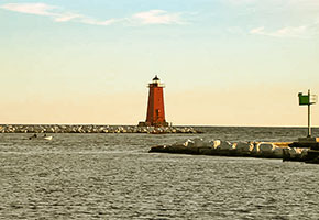
49. Sunken Rock Light
- Location: St. Lawrence River, Alexandria Bay, Jefferson County, NY
- Coordinates: 44°20'10.0"N 75°55'09.0"W (44.3361, -75.9192)
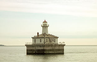
- Status: Active.
- History: The current small iron tower was built in 1913 to replace an 1847 stone lighthouse that was demolished. It marks a hazardous shoal in the middle of the river.
- Viewing Information: A small lighthouse on a rock in the river. It can only be seen by boat.
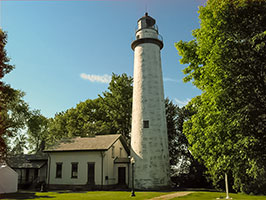
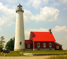
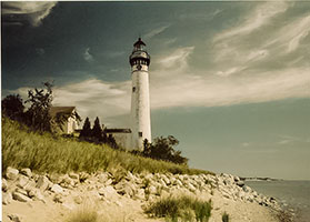
50. Tibbetts Point Lighthouse
- Location: Cape Vincent, Jefferson County, NY
- Coordinates: 44°06'35.0"N 76°22'18.0"W (44.1097, -76.3717)
- Status: Active.
- History: The current 65-foot brick tower was built in 1854, replacing an 1827 original. It marks the point where Lake Ontario meets the St. Lawrence River, a critical navigational point. The keeper's house now operates as a youth hostel.
- Viewing Information: The grounds are open to the public year-round. The tower is occasionally opened for climbs by the preservation society.

[ Back to Top ]
B. The Eastern Great Lakes Region:
(Lake Ontario, Lake Erie, & Lake St. Clair)
[ NY | PA | OH | MI ]
New York
Lake Ontario
(North Shore of New York)
51. Braddock Point Light
- Location: Near Hilton, Monroe County, NY
- Coordinates: 43°20'44.0"N 77°45'40.0"W (43.3456, -77.7611)
- Status: Deactivated. Privately owned.
- History: The original 1896 brick Victorian lighthouse was a stunning structure. The tower was demolished in 1954 due to structural issues. The light was deactivated, and the property was sold. A private owner later built a new, shorter tower that is a replica of the original. It is now a private residence and Bed & Breakfast.
- Viewing Information: The lighthouse is a private residence and not open to the public. It can be viewed from the water or from the nearby Braddock Point Lighhouse Rd.
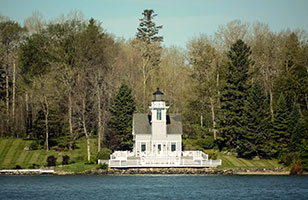
52. Charlotte-Genesee Lighthouse
- Location: Rochester, Monroe County, NY
- Coordinates: 43°15'41.2"N 77°36'28.3"W (43.2614, -77.6079)
- Status: Deactivated. Museum.
- History: An 1822 stone tower, this is the oldest lighthouse on Lake Ontario. It guided ships into the Port of Rochester on the Genesee River. It was deactivated in 1881 but has been beautifully restored by the Charlotte-Genesee Lighthouse Historical Society.
- Viewing Information: The lighthouse and keeper's house museum are open for tours and climbs on weekends from May through November.
53. Cape Vincent Breakwater Light
- Location: Cape Vincent, New York
- Coordinates: 44°710N 76°1956W
- Status: Inactive, has sijremo
- History: Cape Vincent Breakwater Light was a lighthouse on the breakwater protecting the harbor in the town of Cape Vincent, New York. It has been moved to the Town Highway Department on New York State Route 12E.It should not be confused with the nearby Tibbetts Point Light, an active lighthouse also in Cape Vincent.
- Viewing Information:
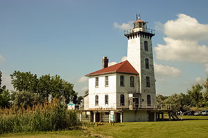
54. Fort Niagara Light
- Location: Youngstown, Niagara County, NY
- Coordinates: 43°15'40.8"N 79°03'47.5"W (43.2613, -79.0632)
- Status: Deactivated.
- History: The current 1872 stone tower stands on the grounds of historic Fort Niagara. It was built to replace an earlier light that was located on the roof of the French Castle within the fort. The tower was raised in 1900 and deactivated in 1993.
- Viewing Information: The lighthouse is located within Fort Niagara State Park, adjacent to the historic fort. The grounds are accessible, but the tower is not generally open to the public.
55. Galloo Island Light
- Location: Galloo Island, Jefferson County, NY
- Coordinates: 43°52'42.0"N 76°27'14.0"W (43.8783, -76.4539)
- Status: Active. Privately owned.
- History: The current 1867 stone tower replaced an 1820 original. It marks the northern entrance to Sackets Harbor. The island and light station were sold and are now a private hunting preserve.
- Viewing Information: Private property and not accessible. It can only be viewed by boat.
56. Genesee West Pier Light
- Location: Rochester, Monroe County, NY
- Coordinates: 43°15'55.0"N 77°36'31.0"W (43.2653, -77.6086)
- Status: Active.
- History: The current 1935 steel tower sits at the end of the west pier at the mouth of the Genesee River. It replaced an earlier 1881 pier light.
- Viewing Information: The lighthouse can be viewed from the adjacent Charlotte Beach or by walking the pier.
57. Horse Island Light
- Location: Sackets Harbor, Jefferson County, NY
- Coordinates: 43°56'24.0"N 76°08'40.0"W (43.9400, -76.1444)
- Status: Deactivated. Privately owned.
- History: An 1870 brick lighthouse that was deactivated in 1957. The island is now connected to the mainland by a causeway and is a private residence.
- Viewing Information: Private property. Can be viewed distantly from the Sackets Harbor Battlefield State Historic Site.
58. Little Sodus Bay West Pier Light
- Location: Fair Haven, Cayuga County, NY
- Coordinates: 43°19'37.0"N 76°42'13.0"W (43.3269, -76.7036)
- Status: Active.
- History: An 1870 wooden pierhead light that was replaced by the current 1937 steel skeletal tower.
- Viewing Information: Can be viewed from the pier within Fair Haven Beach State Park.
59. Oswego West Pierhead Light
- Location: Oswego, Oswego County, NY
- Coordinates: 43°28'09.0"N 76°30'55.0"W (43.4692, -76.5153)
- Status: Active.
- History: The current 1934 tower sits at the end of a long breakwater. It is the fourth lighthouse to serve the busy port of Oswego. The lighthouse was recently restored by the H. Lee White Maritime Museum.
- Viewing Information: Located at the end of a breakwater and is not accessible by foot. It can be viewed from shore, particularly from Breitbeck Park. The museum offers boat tours that include a tour of the lighthouse interior.
60. Oak Orchard Harbor Light
- Location: Point Breeze, Orleans County, NY
- Coordinates: 43°22'25.0"N 78°11'36.0"W (43.3736, -78.1933)
- Status: Active (Private Aid). Replica.
- History: The original 1871 lighthouse was demolished in 1916. In 2010, a local group built a faithful replica of the historic lighthouse on the west pier.
- Viewing Information: The replica can be viewed from the surrounding harbor and is a popular local landmark.
61. Sackets Harbor Light
- Location: Sackets Harbor, Jefferson County, NY
- Coordinates: 43°57'02.0"N 76°07'33.0"W (43.9506, -76.1258)
- Status: Active (Private Aid).
- History: A modern light on a pole. The historic Horse Island Light is often referred to as the Sackets Harbor Light, but this is the official harbor light today.
- Viewing Information: Can be viewed from the Sackets Harbor waterfront.
62. Salmon River Light (Selkirk)
- Location: Port Ontario, Oswego County, NY
- Coordinates: 43°33'56.0"N 76°12'03.0"W (43.5656, -76.2008)
- Status: Active (Private Aid).
- History: An 1838 stone lighthouse that was deactivated in 1858. It was the first U.S. lighthouse to be sold to a private owner. It has been beautifully restored and now operates as an inn. It was relit as a private aid in 1989.
- Viewing Information: The lighthouse operates as the "Selkirk Lighthouse." The grounds are open to guests of the inn and its marina.
63. Sodus Point Lighthouse
- Location: Sodus Point, Wayne County, NY
- Coordinates: 43°16'36.0"N 76°58'31.0"W (43.2767, -76.9753)
- Status: Deactivated. Museum.
- History: The current 1871 stone lighthouse replaced an 1825 original. It was deactivated in 1901 when a new pierhead light was established. The lighthouse and keeper's house are now a popular maritime museum.
- Viewing Information: The museum and grounds are open to the public from May to October. The tower is open for climbs. Summer concerts are often held on the lawn.
64. Sodus Outer Light
- Location: Sodus Point, Wayne County, NY
- Coordinates: 43°17'03.0"N 76°58'20.0"W (43.2842, -76.9722)
- Status: Active.
- History: The current 1938 steel tower is located at the end of the west pier, replacing an earlier 1872 wooden tower.
- Viewing Information: Accessible by walking the pier from Sodus Point Beach Park.
65. Stony Point Light (Lake Ontario)
- Location: Henderson, Jefferson County, NY
- Coordinates: 43°50'45.0"N 76°12'42.0"W (43.8458, -76.2117)
- Status: Deactivated. Privately owned.
- History: An 1869 limestone lighthouse built in the "schoolhouse" style. It was deactivated in 1957 and is now a private residence.
- Viewing Information: Private property. It can be seen from the water or from the end of Lighthouse Road.
66. Thirty Mile Point Light
- Location: Golden Hill State Park, Barker, Niagara County, NY
- Coordinates: 43°22'25.0"N 78°29'05.0"W (43.3736, -78.4847)
- Status: Deactivated.
- History: An 1875 stone lighthouse with an attached keeper's dwelling. It is named for its location, thirty miles east of the Niagara River. The light was deactivated in 1958.
- Viewing Information: Located in Golden Hill State Park. The grounds are open to the public. The keeper's house can be rented for overnight stays, and the tower is occasionally opened for tours.
[ Back to Top ]
New York
Lake Erie
(Western Shore of New York)
67. Barcelona Light
- Location: Barcelona, Chautauqua County, NY
- Coordinates: 42°20'44.0"N 79°35'45.0"W (42.3456, -79.5958)
- Status: Deactivated.
- History: An 1829 stone lighthouse that is historically significant as the very first lighthouse in the world to be powered by natural gas. It was deactivated in 1859. The keeper's house is a private residence.
- Viewing Information: The lighthouse is on the grounds of a private residence but can be easily viewed from the street and the public harbor.
68. Buffalo Harbor South Entrance Light ("Bottle Light")
- Location: Buffalo, Erie County, NY
- Coordinates: 42°50'36.0"N 78°52'55.0"W (42.8433, -78.8819)
- Status: Active.
- History: A 1903 cast-iron lighthouse nicknamed the "Bottle Light" or "Chinaman Light" due to its shape. It sits on a breakwater in Buffalo Harbor.
- Viewing Information: Not accessible by land. Can be viewed from the shore at the Union Ship Canal or by boat.
69. Buffalo Intake Crib Light
- Location: Buffalo, Erie County, NY
- Coordinates: 42°53'44.0"N 78°54'32.0"W (42.8956, -78.9089)
- Status: Active.
- History: A small lighthouse on a large water intake crib built in 1908.
- Viewing Information: Located offshore and is best viewed by boat.
70. Buffalo Main Light
- Location: Buffalo, Erie County, NY
- Coordinates: 42°52'44.2"N 78°53'14.8"W (42.8789, -78.8874)
- Status: Deactivated.
- History: The current 60-foot octagonal stone tower was built in 1833 and is the oldest structure in Buffalo. It was deactivated in 1914. It is often called "The Old Stone Lighthouse."
- Viewing Information: Located at the mouth of the Buffalo River on the grounds of the US Coast Guard Sector Buffalo. The tower can be viewed from the Erie Basin Marina and from Lighthouse Point Park. It is occasionally open for climbs.
71. Buffalo North Breakwater Light
- Location: Buffalo, Erie County, NY
- Coordinates: 42°52'49.0"N 78°53'33.0"W (42.8803, -78.8925)
- Status: Deactivated.
- History: A 1903 bottle-shaped cast-iron tower that was deactivated in 1985. It was moved to a new foundation on the waterfront in 1993.
- Viewing Information: The relocated lighthouse is fully accessible for viewing near the Erie Basin Marina.
72. Dunkirk Lighthouse
- Location: Dunkirk, Chautauqua County, NY
- Coordinates: 42°29'20.9"N 79°21'05.8"W (42.4891, -79.3516)
- Status: Active. Museum.
- History: The current 1875 stone lighthouse is attached to a beautiful Victorian keeper's dwelling. It replaced an 1827 tower. The station now serves as a veterans museum.
- Viewing Information: The lighthouse and museum are open for tours and climbs daily during the summer season.
[ Back to Top ]
Pensylvania (2)
Lake Erie
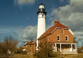
1. Presque Isle Light
- Location: Presque Isle State Park, Erie, Erie County, PA
- Coordinates: 42°09'38.0"N 80°06'56.0"W (42.1606, -80.1156)
- Status: Active.
- History: An 1873 brick tower attached to a keeper's dwelling. The tower was originally 40 feet tall but was raised to 57 feet in 1899. It is the only lighthouse in Pennsylvania on Lake Erie.
- Viewing Information: Located in Presque Isle State Park. The grounds are accessible, and the tower is open for climbs seasonally.
2. Erie Land Light (Replica)
- Location: Erie, Erie County, PA
- Coordinates: 42°08'20.0"N 80°03'51.0"W (42.1389, -80.0642)
- Status: Replica.
- History: The original 1867 sandstone tower was the third lighthouse at this site, but it was decommissioned in 1899 and later demolished. A 55-foot replica of the 1867 tower was built on the original foundation in 2003.
- Viewing Information: Located in a park at the end of a residential street. The grounds are open, but the tower is not.
Ohio (11)
Lake Erie
1. Ashtabula Harbor Light
- Location: Ashtabula, Ashtabula County, OH
- Coordinates: 41°55'17.0"N 80°47'50.0"W (41.9214, -80.7972)
- Status: Active.
- History: The current 1916 steel plate tower was built on a breakwater to replace an earlier 1905 structure. The lighthouse was transferred to a local preservation society in 2011.
- Viewing Information: Located on a detached breakwater and is not accessible. The lighthouse can be viewed from the shore at Walnut Beach Park. The society offers tours during special events.
2. Cleveland East Pierhead Light
- Location: Cleveland, Cuyahoga County, OH
- Coordinates: 41°30'23.0"N 81°40'55.0"W (41.5064, -81.6819)
- Status: Active.
- History: The current 1911 steel tower sits on a breakwater at the entrance to the Cuyahoga River. It is famous for becoming completely encased in dramatic ice formations during winter storms.
- Viewing Information: Not accessible. It can be viewed from the end of the East 9th Street Pier or from Wendy Park.
3. Conneaut Harbor West Breakwater Light
- Location: Conneaut, Ashtabula County, OH
- Coordinates: 41°58'31.0"N 80°33'18.0"W (41.9753, -80.5550)
- Status: Active.
- History: A 1936 steel plate tower on a breakwater. It is a well-preserved example of this style of lighthouse.
- Viewing Information: Not accessible. It can be viewed from the shore at Conneaut Township Park.
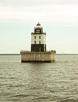
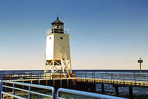
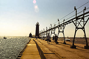
4. Fairport Harbor West Breakwater Light
- Location: Fairport Harbor, Lake County, OH
- Coordinates: 41°46'06.0"N 81°16'54.0"W (41.7683, -81.2817)
- Status: Active.
- History: A 1925 "sparkplug" style lighthouse with an attached fog signal building. It replaced the historic Fairport Harbor Main Light.
- Viewing Information: Located on a breakwater and is not accessible. It can be viewed from the Fairport Harbor Lakefront Park.
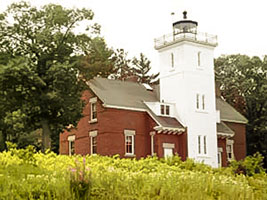
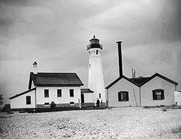
5. Fairport Harbor Main Light (Grand River)
- Location: Fairport Harbor, Lake County, OH
- Coordinates: 41°45'37.0"N 81°16'41.0"W (41.7603, -81.2781)
- Status: Deactivated. Museum.
- History: The current 60-foot sandstone tower was built in 1871, replacing an 1825 tower. It was deactivated in 1925. The lighthouse and keeper's house now serve as the Fairport Harbor Marine Museum.
- Viewing Information: The museum and lighthouse tower are open for climbs on weekends and certain weekdays during the summer.
6. Lorain Harbor Light ("Jewel of the Port")
- Location: Lorain, Lorain County, OH
- Coordinates: 41°28'33.0"N 82°11'06.0"W (41.4758, -82.1850)
- Status: Active (Private Aid).
- History: A 1917 concrete lighthouse on a breakwater. Deactivated in 1965, it was saved from demolition by local efforts. It has been restored and was relit in 1990.
- Viewing Information: Located on a breakwater and is not accessible by foot. It can be viewed from the shore. The Lorain Lighthouse Foundation offers boat tours in the summer.
7. Marblehead Lighthouse
- Location: Marblehead Lighthouse State Park, Ottawa County, OH
- Coordinates: 41°32'11.0"N 82°42'42.0"W (41.5364, -82.7117)
- Status: Active.
- History: Built in 1821, this is the oldest lighthouse in continuous operation on the Great Lakes. The 65-foot conical tower was raised in height in 1900. It is one of the most recognized and photographed landmarks on the Great Lakes.
- Viewing Information: The centerpiece of Marblehead Lighthouse State Park. The grounds are open year-round. The tower is open for climbs daily during the summer.
8. Port Clinton Lighthouse
- Location: Port Clinton, Ottawa County, OH
- Coordinates: 41°30'47.0"N 82°56'07.0"W (41.5131, -82.9353)
- Status: Deactivated. Relocated.
- History: An 1896 wooden pierhead lighthouse. It was deactivated in the 1920s and moved to a private marina. In 2014, it was moved again to its current location on the Port Clinton waterfront and beautifully restored.
- Viewing Information: The lighthouse is fully accessible for viewing in a city park on the waterfront. It is open for tours on weekends.
9. South Bass Island Light
- Location: South Bass Island (Put-in-Bay), Ottawa County, OH
- Coordinates: 41°38'07.0"N 82°49'54.0"W (41.6353, -82.8317)
- Status: Deactivated.
- History: A unique 1897 two-story brick Queen Anne style house with a square tower. The lighthouse is now owned by Ohio State University and is used for research and student housing.
- Viewing Information: The grounds are open to the public during limited hours on certain weekdays. The tower is open for special tours a few times a year.
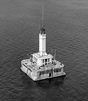
10. Toledo Harbor Light
- Location: Lake Erie, off Toledo, Lucas County, OH
- Coordinates: 41°45'46.0"N 83°19'44.0"W (41.7628, -83.3289)
- Status: Active.
- History: A unique 1904 Romanesque style lighthouse built on a large offshore crib. It is known for its intricate brickwork and iron details. It was automated in 1965.
- Viewing Information: Not accessible. It is located 8 miles offshore and can only be viewed by private boat or on special lighthouse cruises.
11. Vermilion Lighthouse (Replica)
- Location: Vermilion, Erie County, OH
- Coordinates: 41°25'33.0"N 82°21'43.0"W (41.4258, -82.3619)
- Status: Active (Private Aid).
- History: The original 1877 lighthouse was moved to Lake Ontario in 1929. In 1991, a dedicated group of citizens built this faithful replica on the Vermilion waterfront.
- Viewing Information: Located in a public park at the Inland Seas Maritime Museum. The grounds are accessible, but the tower is not open for climbs.
Michigan (158)
(State w/greatest number of lighthouses in the United States, officially the number is 129, this exhaustive list includes lighthouses that are inactive or no longer standing.)
Lake Erie
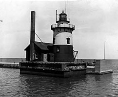
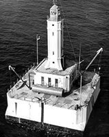
1. Detroit River Light, Rockwood, MI
- Location: Detroit River,
- Coordinates: 42.00075°N 83.14068°W
- Status: Active
- History: ?
- Viewing Information: ?
2. Monroe Pier Light
- Location: Monroe, Mi
- Coordinates: ?
- Status: Active
- History: ?
- Viewing Information: ?
[ Back to Top ]
Michigan (
Lake St. Clair, The Detroit River, & Clinton River
3.  Grosse Ile North Channel Front Range Light Grosse Ile North Channel Front Range Light
- Location: Grosse Ile, Detroit River, Wayne County, MI
- Coordinates: 42°09'30.0"N 83°08'09.0"W (42.1583, -83.1358)
- Status: Deactivated. Relocated.
- History: A 1906 skeletal tower that once stood offshore in Lake St. Clair. It was saved from demolition by the Grosse Ile Historical Society and moved to the grounds of a former Air Force base.
- Viewing Information: The lighthouse can be viewed on the grounds of the Grosse Ile Municipal Airport.
4. Clinton River Light
- Location: Lake St. Clair and Clinton River, Mount Clemens, MI
- Coordinates:?
- Status: Inactive
- History: Built in 1847, no longer standing
- Viewing Information:
5. Lake St. Clair Light
- Location: Lake St. Clair, MI
- Coordinates: 42°28'00.0"N 82°45'30.0"W (42.4667, -82.7583)
- Status: Deactivated.
- History: A round, crib-based lighthouse built in 1941 to replace a lightship. It was deactivated in the 1990s.
- Viewing Information: Not accessible. Can only be viewed by boat.
6. .jpg) Mariners Memorial (River Rouge) Light Mariners Memorial (River Rouge) Light
- Location: Detroit River, River Rouge,
- Coordinates: 42.27101°N 83.11128°W
- Status: Active
- History:
- Viewing Information:
7.  Peche Island Light (Windmill Point) Peche Island Light (Windmill Point)
- Location: Detroit River, Detroit, Wayne County, MI
- Coordinates: 42°21'06.0"N 82°55'54.0"W (42.3517, -82.9317)
- Status: Active.
- History: The current 1933 tower replaced an earlier 1883 structure. It marks the entrance to the Detroit River from Lake St. Clair.
- Viewing Information: Located in a city park (Mariners Park) in Detroit. The grounds are accessible, but the tower is not.
8. St. Clair Flats Canal Light
- Location: Lake St. Clair, St. Clair County, MI
- Coordinates: 42°33'48.0"N 82°44'24.0"W (42.5633, -82.7400)
- Status: Deactivated.
- History: An 1871 "schoolhouse" style lighthouse. The tower was removed in the 1930s, and the building is now in ruins.
- Viewing Information: The ruins are on a shoal and only visible by boat.
9. Tri-Centennial Light of Detroit
- Location: Detroit River, Detroit, Wayne County, MI
- Coordinates: 42.33229°N 83.02509°W
- Status: Active
- History: ?
- Viewing Information: Can be accessed from within Miliken State Park
10. William Livingstone Memorial Light
- Location: Belle Isle, Detroit, Wayne County, MI
- Coordinates: 42°19'53.0"N 82°58'27.0"W (42.3314, -82.9742)
- Status: Active.
- History: A unique and beautiful 58-foot white marble lighthouse designed by noted architect Albert Kahn. It was built in 1930 and is the only lighthouse in the nation built of marble. It was erected in memory of William Livingstone, president of the Lake Carriers Association.
- Viewing Information: Located in Belle Isle Park. The grounds are fully accessible, but the tower is not open to the public.
11.  Windmill Point Lights Windmill Point Lights
- Location: Detroit River, Detroit, Wayne County, MI
- Coordinates: 42.35756°N 82.92996°W
- Status: Active
- History: Built in 1933
- Viewing Information: Can be accessed from within Riverfront Lakewood Park
12. Ecorse Lights (Front and Rear Lights)
- Location: Detroit River, Ecourse, Wayne County, MI
- Coordinates: ?
- Status: Inactive
- History: Built between 1894 and 1895, No longer standing
13. Gibralter Light
- Location: Detroit River, Gibralter, MI
- Coordinates:
- Status: Inactive
- History: Originally built in 1838 and rebuilt in 1873, No longer standing
14. Grassy Island North and South Channel Range Lights
- Location: Detroit River, Grassy Island, MI
- Coordinates: ?
- Status: Inactive
- History: South light was originally built in 1849 and rebuilt in 1896. North tower built in 1897, No longer standing
 15. Mama Juda Light 15. Mama Juda Light
- Location: Detroit River, Mamajuda Island, MI
- Coordinates:
- Status: Inactive
- History: No longer standing
16. Mama Juda Range Front Light
- Location: Detroit River, Mamajuda Island, MI
- Coordinates: ?
- Status: Inactive
- History: No longer standing
17. Miller Memorial Light
- Location: Lake St. Clair, St. Clair Shores, MI
- Coordinates: 42.46375°N 82.87917°W
- Status: Active
- History: ?
- Viewing Information:?
18. Grosse Ile North Channel and Range Lights
- Location: Detroit River, Grosse Ile, MI
- Coordinates: ?
- Status: Inactive
- History: originally built in 1894, rebuilt in 1906, rear light is no longer standing while front light is still standing but inactive.
[ Back to Top ]
C. The Western Great Lakes Region:
(Lake Huron, Lake Michigan, & Lake Superior)
[ MI | IL | IN | WI | MN ]
Michigan's East Shore & North Shore
Lake Huron
(Includes The Straits of Mackinac, Lake Nicolet, Munuscong Lake, & Potagannissing Bay)
19. Alpena Light ("Sputnik")
- Location: Alpena, Alpena County, MI
- Coordinates: 45°03'39.0"N 83°25'48.0"W (45.0608, -83.4300)
- Status: Active.
- History: A 1914 steel skeletal tower, this starkly modern lighthouse is often called "Sputnik" or "Little Chet" for its resemblance to a satellite. It marks the entrance to the Thunder Bay River.
- Viewing Information: Located at the end of a breakwater. It can be viewed well from the Alpena marina and waterfront.
 20. Au Sable North Pierhead Light 20. Au Sable North Pierhead Light
- Location: Lake Huron, Au Sable, Iosco County, MI
- Coordinates: 44.40662°N 83.3165°W
- Status: Active
- History: ?
- Viewing Information: Located at the end of a breakwater. It can be viewed well from the Au Sable park and waterfront.
21. Caseville Harbor Light
- Location: Lake Huron, Caseville, MI
- Coordinates: 43.94347°N 83.27278°W
- Status: Active
- History: ?
- Viewing Information: Breakwater Light, can be viewd from beach and breakwater.
22. Bois Blanc Island Lighthouse
- Location: Bois Blanc Island, Mackinac County, MI
- Coordinates: 45°48'56.0"N 84°24'38.0"W (45.8156, -84.4106)
- Status: Deactivated. In ruins.
- History: An 1839 brick tower that was abandoned after a new lighthouse was built on the island in 1867. The tower now stands as a crumbling ruin.
- Viewing Information: The island is accessible by ferry, but the ruins are on private property and not accessible.
 23. Charity Island Light 23. Charity Island Light
- Location: Saginaw Bay, Lake Huron, Charity Island, Whitney Township, Arenac County, MI
- Coordinates: 44.03139°N 83.43556°W
- Status: Inactive
- History: Built in 1857
- Viewing Information: Vieawble by boat
24.  Cheboygan Crib Light Cheboygan Crib Light
- Location: Cheboygan, Cheboygan County, MI
- Coordinates: 45°39'25.0"N 84°27'38.0"W (45.6569, -84.4606)
- Status: Active (Private Aid).
- History: An 1884 wooden lighthouse that was moved from the mouth of the Cheboygan River onto a crib in the lake. It was saved from demolition and is maintained by a preservation society.
- Viewing Information: The lighthouse can be viewed well from Gordon Turner Park in Cheboygan.
25. Cheboygan River Front Range Light
- Location: Cheboygan, Cheboygan County, MI
- Coordinates: 45°39'08.0"N 84°27'56.0"W (45.6522, -84.4656)
- Status: Deactivated. Relocated.
- History: An 1880 wooden range light that was moved from its original location to the Cheboygan County Historical Museum.
- Viewing Information: The lighthouse is an exhibit at the historical museum and is fully accessible.
26. De Tour Reef Light
 Location: De Tour Passage, Chippewa County, MI Location: De Tour Passage, Chippewa County, MI- Coordinates: 45°56'57.0"N 83°54'08.0"W (45.9492, -83.9022)
- Status: Active.
- History: A massive 1931 concrete lighthouse built on a crib in the middle of the busy shipping channel connecting Lake Huron and the St. Marys River. It replaced a lightship. The station is being restored by a preservation society.
- Viewing Information: Not accessible by land. The De Tour Reef Lighthouse Preservation Society offers tours and overnight keeper programs during the summer.
27.  Fort Gratiot Lighthouse Fort Gratiot Lighthouse
- Location: Port Huron, St. Clair County, MI
- Coordinates: 43°00'23.0"N 82°24'27.0"W (43.0064, -82.4075)
- Status: Active.
- History: The first lighthouse in Michigan, established in 1825. The current 82-foot brick tower was built in 1861 and marks the entrance to the St. Clair River from Lake Huron.
- Viewing Information: Located in a public park. The grounds are open, and the tower is open for climbs seasonally for a fee.
28.  Fourteen Foot Shoal Light Fourteen Foot Shoal Light
- Location: Lake Huron, Cheboygan County
- Coordinates: 45.67981°N 84.435°W
- Status: Active
- History: ?
- Viewing Information:
 29. Forty Mile Point Lighthouse 29. Forty Mile Point Lighthouse
- Location: Rogers City, Presque Isle County, MI
- Coordinates: 45.48667°N 83.91333°W
- Status: Active
- History: An 1897 brick tower attached to a keeper's dwelling. It was built to mark a dangerous, 40-mile stretch of coastline between existing lights.
- Viewing Information: Located in a county park. The grounds, keeper's house museum, and tower are open to the public seasonally.
30. Frechette Point Range Front Light
- Location: St. Marys River, Chippewa County, MI
- Coordinates: 46°16'54.0"N 84°12'24.0"W (46.2817, -84.2067)
- Status: Active.
- History: A modern 1960s range light on a skeletal tower.
- Viewing Information: Not accessible. Best viewed by boat.
31. Frying Pan Island Light
- Location: St. Marys River, Chippewa County, MI
- Coordinates: 46°01'36.0"N 83°57'36.0"W (46.0267, -83.9600)
- Status: Active.
- History: An 1882 lighthouse on a small island.
- Viewing Information: Not accessible. Best viewed by boat.
32.  Gravelly Shoal Light Gravelly Shoal Light
- Location: Saginaw Bay, Arenac County, MI
- Coordinates: 44°01'36.0"N 83°32'00.0"W (44.0267, -83.5333)
- Status: Active.
- History: A 1939 Art Deco style offshore lighthouse.
- Viewing Information: Not accessible. Can only be seen by boat.
 33. Harbor Beach Light (Sand Beach) 33. Harbor Beach Light (Sand Beach)
- Location: Harbor Beach, Huron County, MI
- Coordinates: 43°50'44.0"N 82°37'50.0"W (43.8456, -82.6306)
- Status: Active.
- History: An 1885 "sparkplug" style lighthouse built to mark the entrance to the harbor of refuge.
- Viewing Information: Located on a breakwater and is not accessible by foot. The Harbor Beach Lighthouse Preservation Society offers boat tours to the lighthouse.
34. Huron Lightship
- Location: Port Huron, St. Clair County, MI
- Coordinates: 42°58'27.0"N 82°25'08.0"W (42.9742, -82.4189)
- Status: Museum Ship. National Historic Landmark.
- History: The last lightship to serve on the Great Lakes, the WLV-526 was built in 1920. It served at various stations before being stationed at Corsica Shoals in Lake Huron in 1935, where it remained until its decommissioning in 1970.
- Viewing Information: The lightship is a main exhibit at the Port Huron Museum and is open for tours.
35. Mackinac Point Lighthouse
- Location: Mackinaw City, Cheboygan County, MI
- Coordinates: 45°47'20.0"N 84°43'41.0"W (45.7889, -84.7281)
- Status: Deactivated. Museum.
- History: An 1892 lighthouse designed to look like a castle. It was a critical light for ships passing through the busy Straits of Mackinac. It was deactivated in 1957 after the Mackinac Bridge was completed, rendering the light obsolete.
- Viewing Information: Part of the Mackinac State Historic Parks system. The beautifully restored keeper's quarters and tower are open for tours with an admission fee.
36. Martin Reef Light
- Location: Lake Huron, Mackinac County, MI
- Coordinates: 45°54'12.0"N 84°08'42.0"W (45.9033, -84.1450)
- Status: Active.
- History: A 1927 offshore lighthouse built on a pier in the same style as Poe Reef Light.
- Viewing Information: Not accessible. Can only be viewed by boat on specialized lighthouse cruises.
 37. Middle Island Lighthouse 37. Middle Island Lighthouse
- Location: Middle Island, Alpena County, MI
- Coordinates: 45°11'40.0"N 83°19'30.0"W (45.1944, -83.3250)
- Status: Active.
- History: An 1905 brick tower and keeper's house built to mark a dangerous shoal between Thunder Bay and Presque Isle.
- Viewing Information: The island is accessible by private boat. The Middle Island Lighthouse Preservation Society is restoring the station and sometimes offers tours.
 38. Minneapolis Shoal Light 38. Minneapolis Shoal Light
- Location: Lake Huron, Big Bay de Noc, MI
- Coordinates: 45.53611°N 86.99833°W
- Status: Active
- History: Built in 1935
- Viewing Information: Vieable from shore and by boat.
39. New Presque Isle Lighthouse
- Location: Presque Isle, Presque Isle County, MI
- Coordinates: 45°21'23.0"N 83°29'43.0"W (45.3564, -83.4953)
- Status: Active.
- History: Built in 1870 to replace the Old Presque Isle Light, this 113-foot brick tower is one of the tallest lighthouses on the Great Lakes open for public climbing.
- Viewing Information: Located in a public park. The tower and keeper's house museum are open for climbs seasonally for a fee.
 40. Old Presque Isle Lighthouse 40. Old Presque Isle Lighthouse
- Location: Presque Isle, Presque Isle County, MI
- Coordinates: 45°19'27.0"N 83°28'27.0"W (45.3242, -83.4742)
- Status: Deactivated. Museum.
- History: A charming 1840 brick lighthouse that served for only 31 years before being replaced by the New Presque Isle Light. It is said to be haunted by a former keeper.
- Viewing Information: The grounds, keeper's house museum, and tower are open seasonally for a fee.
41. Pipe Island Light
- Location: St. Marys River, Chippewa County, MI
- Coordinates: 46°03'30.0"N 84°00'36.0"W (46.0583, -84.0100)
- Status: Active. Privately owned.
- History: An 1888 brick lighthouse on a small island. It is now a private residence.
- Viewing Information: Private property. Can be viewed by boat.
 42. Poe Reef Light 42. Poe Reef Light
- Location: Straits of Mackinac, Cheboygan County, MI
- Coordinates: 45°41'42.0"N 84°21'48.0"W (45.6950, -84.3633)
- Status: Active.
- History: A 1929 black and white striped offshore lighthouse built on a concrete crib. It marks a dangerous reef.
- Viewing Information: Not accessible. Can only be viewed on specialized lighthouse cruises.
 43. Pointe aux Barques Lighthouse 43. Pointe aux Barques Lighthouse
- Location: Port Hope, Huron County, MI
- Coordinates: 44°01'18.0"N 82°47'29.0"W (44.0217, -82.7914)
- Status: Active.
- History: The current 89-foot tower was built in 1857, replacing an 1848 original. It marks the dangerous point at the tip of Michigan's "Thumb."
- Viewing Information: Located in a county park. The keeper's house is a museum, and the tower is open for climbs on select dates.
 44. Port Austin Reef Light 44. Port Austin Reef Light
- Location: Port Austin, Huron County, MI
- Coordinates: 44°04'28.0"N 82°58'50.0"W (44.0744, -82.9806)
- Status: Deactivated.
- History: An 1878 brick lighthouse built on a crib nearly 2.5 miles offshore to mark a dangerous reef. It was deactivated in 1952. A local society is working to restore it.
- Viewing Information: Not accessible. It can be viewed from the shore at Port Austin.
45. Port Sanilac Lighthouse
- Location: Port Sanilac, Sanilac County, MI
- Coordinates: 43°25'42.0"N 82°32'30.0"W (43.4283, -82.5417)
- Status: Active. Privately owned.
- History: An 1886 brick lighthouse with a distinctive octagonal tower. It is now a private residence.
- Viewing Information: Private property and not open to the public. It can be viewed well from the street and the adjacent harbor.
46.  Presque Isle Front Range Light Presque Isle Front Range Light
- Location: Presque Isle, Presque Isle County, MI
- Coordinates: 45°21'26.0"N 83°29'20.0"W (45.3572, -83.4889)
- Status: Active.
- History: A small 1870 wooden tower that served as the front light for a range with the Old Presque Isle Light as the rear.
- Viewing Information: Located in the same park as the New Presque Isle Light. The grounds are accessible.
47. Round Island Lighthouse
- Location: Straits of Mackinac, Mackinac County, MI
- Coordinates: 45°50'13.0"N 84°37'02.0"W (45.8369, -84.6172)
- Status: Active (Private Aid).
- History: An iconic 1895 red and white brick lighthouse that is a classic part of the Mackinac scenery. It fell into disrepair after being abandoned but has been restored by preservationists.
- Viewing Information: Located on an island that is part of the Hiawatha National Forest. It is not open to the public but is a highlight of all ferry trips to Mackinac Island.
 48. Round Island Passage Light 48. Round Island Passage Light
- Location: Straits of Mackinac, Mackinac County, MI
- Coordinates: 45°50'45.0"N 84°39'23.0"W (45.8458, -84.6564)
- Status: Active.
- History: A 1948 concrete lighthouse that was the last manned lighthouse built by the U.S. government on the Great Lakes. It was automated in 1973.
- Viewing Information: Not accessible. Can be seen from the Mackinac Bridge and from ferries.
 49. Round Island Light (St. Marys River) 49. Round Island Light (St. Marys River)
- Location: St. Marys River, Chippewa County, MI
- Coordinates: 46°13'06.0"N 84°15'06.0"W (46.2183, -84.2517)
- Status: Active.
- History: An 1892 lighthouse on a pier.
- Viewing Information: Not accessible. Best viewed by boat.
 50. Saginaw River Rear Range Light 50. Saginaw River Rear Range Light
- Location: Near Bay City, Bay County, MI
- Coordinates: 43°38'42.0"N 83°50'00.0"W (43.6450, -83.8333)
- Status: Deactivated.
- History: An 1876 lighthouse that is now severely endangered and in a state of ruin.
- Viewing Information: Not accessible and is on private property.
51. Spectacle Reef Light
- Location: Straits of Mackinac, Mackinac County, MI
- Coordinates: 45°46'31.0"N 84°08'14.0"W (45.7753, -84.1372)
- Status: Active. Privately owned.
- History: An 1874 stone lighthouse considered one of the most heroic engineering feats on the Great Lakes. It was built on a treacherous submerged reef in a very remote location.
- Viewing Information: Not accessible. It is 11 miles from the nearest land and can only be seen by private boat or on special lighthouse cruises.
52. St. Martin Island Light
- Location: St. Martin Island, Mackinac County, MI
- Coordinates: 45°41'36.0"N 84°06'18.0"W (45.6933, -84.1050)
- Status: Active.
- History: A 1905 offshore lighthouse.
- Viewing Information: Not accessible. Can only be viewed by boat.
 53. Sturgeon Point Lighthouse 53. Sturgeon Point Lighthouse
- Location: Harrisville, Alcona County, MI
- Coordinates: 44°45'40.0"N 83°16'18.0"W (44.7611, -83.2717)
- Status: Active.
- History: An 1869 brick tower with an attached keeper's house. The station is now managed by the Alcona Historical Society as a maritime museum.
- Viewing Information: The museum is open seasonally, and the tower is open for climbs on a regular schedule during the summer.
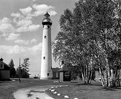
 54. Tawas Point Lighthouse 54. Tawas Point Lighthouse
- Location: Tawas Point State Park, Iosco County, MI
- Coordinates: 44°15'11.0"N 83°27'31.0"W (44.2531, -83.4586)
- Status: Deactivated.
- History: The current 1876 brick tower replaced an earlier light. It is located on a sandy spit that is a major bird migration route.
- Viewing Information: Located within Tawas Point State Park. The tower is open for tours seasonally, and the keeper's house is available for a keeper-in-residence program.
 55. Thunder Bay Island Lighthouse 55. Thunder Bay Island Lighthouse
- Location: Thunder Bay Island, Alpena County, MI
- Coordinates: 45°02'20.0"N 83°11'20.0"W (45.0389, -83.1889)
- Status: Active.
- History: The current 1857 stone tower is one of the oldest on Lake Huron. The station also had one of the first steam-powered fog signals on the Great Lakes.
- Viewing Information: The island is remote and not easily accessible. It can be seen on some shipwreck boat tours out of Alpena.
St. Marys River (Connects Huron & Superior)
56. Frying Pan Island Light
- Location: St. Marys River, De Tour Village, Chippewa County, MI
- Coordinates: 45.98545°N 83.89471°W
- Status:
- History:
- Viewing Information:
57. Frechette Point Range Front Light
- Location: St. Marys River, Chippewa County, MI
- Coordinates: 46°16'54.0"N 84°12'24.0"W (46.2817, -84.2067)
- Status: Active.
- History: A modern 1960s range light on a skeletal tower. It works with its rear range counterpart to guide down-bound traffic in the St. Marys River.
- Viewing Information: Not accessible. It is located on private property and is best viewed by boat.
58. Frechette Point Range Rear Light
- Location: St. Marys River, Chippewa County, MI
- Coordinates: 46°17'14.5"N 84°12'31.7"W (46.2874, -84.2088)
- Status: Active.
- History: The taller of the two Frechette Point range lights, this skeletal tower was also built in the 1960s.
- Viewing Information: Not accessible. It is located on private property and is best viewed by boat.
59. Harwood Point East Range Front Light
- Location: St. Marys River, Sugar Island, Chippewa County, MI
- Coordinates:
- Status:
- History:
- Viewing Information:
60. Middle Lake George Light
- Location: St. Marys River, Sugar Island, Chippewa County, MI
- Coordinates:
- Status:
- History:
- Viewing Information:
61. Pipe Island Light
- Location: St. Marys River, Chippewa County, MI
- Coordinates: 46°03'30.0"N 84°00'36.0"W (46.0583, -84.0100)
- Status: Active. Privately owned.
- History: An 1888 brick lighthouse on a small island near the entrance to the De Tour Passage. It was deactivated and sold, but the new owners have kept it lit as a private aid to navigation.
- Viewing Information: The lighthouse is a private residence and is not open to the public. It can be viewed by boat.
62. Pointe aux Pins Front Range Light
- Location: Bois Blanc Island, Mackinac County, MI
- Coordinates: 45°46'30.0"N 84°28'30.0"W (45.7750, -84.4750)
- Status: Deactivated.
- History: A small wooden structure built in 1893 that served as a front range light.
- Viewing Information: Located on private property on Bois Blanc Island and is not accessible.
63. Pointe aux Pins Rear Range Light
- Location: Bois Blanc Island, Mackinac County, MI
- Coordinates: 45°46'30.0"N 84°28'30.0"W (45.7750, -84.4750)
- Status: Deactivated.
- History: The 1893 rear range light that worked with the front range light.
- Viewing Information: Located on private property on Bois Blanc Island and is not accessible.
64. Round Island Light (St. Marys River)
- Location: St. Marys River, Chippewa County, MI
- Coordinates: 46°13'06.0"N 84°15'06.0"W (46.2183, -84.2517)
- Status: Active.
- History: An 1892 lighthouse on a pier, located in the lower St. Marys River. This is a different Round Island Light than the more famous one in the Straits of Mackinac.
- Viewing Information: Not accessible. It can only be viewed by boat.
65. Six Mile Point Range Rear Light
- Location: St. Marys River, Chippewa County, MI
- Coordinates:
- Status:
- History:
- Viewing Information:
66. St. Mary's River Lower Range Front Light
- Location: St. Marys River, Chippewa County, MI
- Coordinates:
- Status:
- History:
- Viewing Information:
67. Vidal Shoals Channel Front & Rear Range Lights
- Location: Sault Ste. Marie, Chippewa County, MI
- Coordinates: 46.5045°N 84.36374°W (Rear) 46.50392°N 84.36715°W (front)
- Status: Deactivated.
- History: These lights were on the grounds of the former U.S. Coast Guard station in Sault Ste. Marie and guided traffic near the Soo Locks.
- Viewing Information: The lights are no longer active and the area is not generally open to the public.
68. Winter Point Range Front Light
- Location: St. Marys River, Chippewa County, MI
- Coordinates: 46.22608°N 84.14409°W
- Status: Active
- History: ?
[ Back to Top ]
Michigan's West Shore
Lake Michigan
(Includes Green Bay, Grand Traverse Bay, & The Chicago River)
Michigan (Lower Peninsula)
69. Beaver Island Harbor Light (St. James)
- Location: Beaver Island, Charlevoix County, MI
- Coordinates: 45°45'00.0"N 85°30'47.0"W (45.7500, -85.5131)
- Status: Deactivated. Museum.
- History: The current 1870 brick tower replaced an 1856 original. It served the fishing and lumbering port of St. James. It was deactivated in 1962 and is now part of a maritime museum.
- Viewing Information: The lighthouse is located in a public park in the town of St. James on Beaver Island, which is accessible by ferry. The tower is open for climbs as part of the museum.
 70. Beaver Island Lighthouse (Beaver Head) 70. Beaver Island Lighthouse (Beaver Head)
- Location: Beaver Island, Charlevoix County, MI
- Coordinates: 45°35'46.0"N 85°35'15.0"W (45.5961, -85.5875)
- Status: Deactivated.
- History: An 1858 brick tower, it is located on the southern tip of Beaver Island. The station was the site of an alternative school for a period after its deactivation in 1961.
- Viewing Information: The lighthouse is located in a remote part of the island, accessible by road. The grounds are open, but the tower is generally not open to the public.
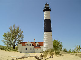 71. Big Sable Point Lighthouse 71. Big Sable Point Lighthouse
- Location: Ludington State Park, Mason County, MI
- Coordinates: 44°03'31.0"N 86°30'56.0"W (44.0586, -86.5156)
- Status: Active.
- History: A stunning 112-foot brick tower built in 1867. Its original brick was deteriorating, so it was encased in steel plates in 1900, giving it the iconic black and white banded appearance.
- Viewing Information: Located within Ludington State Park. Access requires a 1.8-mile walk or bike ride on a dedicated trail. The tower is open for climbs seasonally.
72. Cedar River Light
- Location: Lake Michigan, Cedar River, Cedarville Township, Meniminee County, MI
- Coordinates:
- Status:
- History:
- Viewing Information:
 73. Charlevoix South Pier Light Station 73. Charlevoix South Pier Light Station
- Location: Charlevoix, Charlevoix County, MI
- Coordinates: 45°19'06.0"N 85°15'54.0"W (45.3183, -85.2650)
- Status: Active.
- History: The current 1948 steel tower sits at the end of the south pier, replacing earlier wooden structures. It is a well-known local landmark.
- Viewing Information: The lighthouse is accessible by walking the pier from Lake Michigan Beach Park.
74. Frankfort North Breakwater Light
- Location: Frankfort, Benzie County, MI
- Coordinates: 44°37'56.0"N 86°15'04.0"W (44.6322, -86.2511)
- Status: Active.
- History: The current 1932 steel tower sits at the end of the north breakwater. It was one of the last manned pierhead lights on the lake.
- Viewing Information: The lighthouse is accessible by walking the pier.
 75. Grand Haven South Pierhead Inner & Entrance Lights 75. Grand Haven South Pierhead Inner & Entrance Lights
- Location: Grand Haven State Park, Ottawa County, MI
- Coordinates: 43°03'24.0"N 86°15'24.0"W (43.0567, -86.2567)
- Status: Active.
- History: A beloved pair of 1905 red pier lights connected by a lighted catwalk, offering beautiful sunset photo opportunities.
- Viewing Information: Fully accessible by walking the pier from Grand Haven State Park.
76. Grand Traverse Lighthouse
- Location: Leelanau State Park, Leelanau County, MI
- Coordinates: 45°15'35.0"N 85°32'48.0"W (45.2597, -85.5467)
- Status: Deactivated. Museum.
- History: The current 1858 brick tower and keeper's house marked the entrance to Grand Traverse Bay. The station has been restored to its 1920s-30s appearance.
- Viewing Information: Located within Leelanau State Park. The keeper's quarters museum and tower are open for tours seasonally.
 77. Grays Reef Light 77. Grays Reef Light
- Location: Lake Michigan, Bliss Township, Emmet County, MI
- Coordinates: 45.76667°N 85.15333°W
- Status: Active
- History: Originally built in 1891 and rebuilt in 1936
- Viewing Information: Vieable by boat
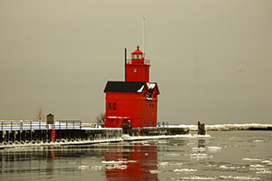 78. Holland Harbor Lighthouse ("Big Red") 78. Holland Harbor Lighthouse ("Big Red")
- Location: Holland, Ottawa County, MI
- Coordinates: 42°46'22.0"N 86°12'53.0"W (42.7728, -86.2147)
- Status: Active.
- History: One of Michigan's most famous lighthouses, this striking red, twin-gabled structure was built in 1907. It stands at the entrance to Lake Macatawa.
- Viewing Information: The lighthouse is on private property with no public access. It is best viewed from across the channel at Holland State Park.
 79. Ile Aux Galets Light ("Skillagalee") 79. Ile Aux Galets Light ("Skillagalee")
- Location: Near Beaver Island, Charlevoix County, MI
- Coordinates: 45°40'30.0"N 85°09'48.0"W (45.6750, -85.1633)
- Status: Active.
- History: The current 1888 tower on a remote, barren island replaced earlier, inadequate lights. The name "Skillagalee" is a corruption of its French name.
- Viewing Information: Not accessible. It is located 7 miles from the nearest mainland and can only be seen on specialized lighthouse cruises.
80. Kalamazoo River Light (Saugatuck Light)
- Location: Saugatuck, Allegan County, MI
- Coordinates: 42°39'26.0"N 86°12'42.0"W (42.6572, -86.2117)
- Status: Deactivated. Relocated.
- History: An 1859 lighthouse that was deactivated in 1914. The lantern and tower were later moved to the Saugatuck-Douglas Historical Society Museum.
- Viewing Information: A replica stands near the original location, while the original lantern is at the museum.
 81. Lansing Shoals Light 81. Lansing Shoals Light
- Location: Lake Michigan, Newton Township, Mackinac County,
- Coordinates: 45.90333°N 85.56167°W
- Status: Active
- History: Orinally built in 1900, renovated in 1928
- Viewing Information: Viewable by boat
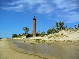 82. Little Sable Point Lighthouse 82. Little Sable Point Lighthouse
- Location: Silver Lake State Park, Oceana County, MI
- Coordinates: 43°39'19.0"N 86°32'18.0"W (43.6553, -86.5383)
- Status: Active.
- History: A graceful, 107-foot tall red brick tower built in 1874. Unlike many other lights, it was never painted white or encased in steel.
- Viewing Information: The grounds are accessible within Silver Lake State Park. The tower is open for climbs during the summer season for a fee.
 83. Little Traverse Lighthouse 83. Little Traverse Lighthouse
- Location: Harbor Springs, Emmet County, MI
- Coordinates: 45°25'36.0"N 84°58'36.0"W (45.4267, -84.9767)
- Status: Deactivated.
- History: An 1884 brick tower attached to a keeper's dwelling. It now serves as the clubhouse for a private yacht club.
- Viewing Information: Private property. Can be viewed from the water.
 84. Ludington North Breakwater Light 84. Ludington North Breakwater Light
- Location: Ludington, Mason County, MI
- Coordinates: 43°57'02.0"N 86°28'10.0"W (43.9506, -86.4694)
- Status: Active.
- History: A 1924 steel-plated tower on the north breakwater. It is a well-known sight for passengers on the S.S. Badger car ferry.
- Viewing Information: The lighthouse is accessible by walking the breakwater from Stearns Park.
85. Manistee Main Light
- Location: Lake Michigan, Manistee, Manistee County, MI
- Coordinates: ?
- Status: Inactive
- History: No longer standing
 86. Manistee North Pierhead Light 86. Manistee North Pierhead Light
- Location: Manistee, Manistee County, MI
- Coordinates: 44°15'04.0"N 86°20'42.0"W (44.2511, -86.3450)
- Status: Active.
- History: The current 1927 cast-iron tower is connected to the shore by a unique elevated catwalk. It is one of only four catwalks remaining in Michigan.
- Viewing Information: The lighthouse is accessible by walking the pier from the 5th Avenue Beach.
 87. Manistique East Breakwater Light 87. Manistique East Breakwater Light
- Location: Lake Michigan, Manistique, Manistee County, MI
- Coordinates: 45.94478°N 86.24765°W
- Status: Active
- History: Built between 1915-1917
- Viewing Information: Viewable from the breakwater
 88. Manning Memorial Light 88. Manning Memorial Light
- Location: Lake Michigan, Empire, Lealanau County, MI
- Coordinates: 44.80793°N 86.25521°W
- Status: Active
- History: Built in 1990
- Viewing Information: Viewable by boat
 89. McGulpin Point Lighthouse 89. McGulpin Point Lighthouse
- Location: Straits of Mackinac. Mackinaw City, Wawatam Township, Emmet County, MI
- Coordinates: 45.7869°N 84.7722°W
- Status: Active (Private Aid).
- History: An 1869 brick lighthouse that was deactivated in 1906. After decades as a private residence, it was purchased by the county, restored, and relit in 2009.
- Viewing Information: The grounds and tower are open to the public seasonally.
 90. Menominee North Pier Light (Also known as Marinette North Pier Light) 90. Menominee North Pier Light (Also known as Marinette North Pier Light)
- Location: Lake Michigan, Menominee, Menominee County, MI
- Coordinates: 45.11392°N 87.58603°W
- Status: Active
- History: Built in 1887 and rebuilt in 1927
- Viewing Information: Viewable from pier and waterfront.
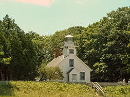 91. Mission Point Lighthouse (site of original tower that was replaced in 1933) 91. Mission Point Lighthouse (site of original tower that was replaced in 1933)
- Location: Traverse City, Grand Traverse County, MI
- Coordinates: 45°05'20.0"N 85°28'24.0"W (45.0889, -85.4733)
- Status: Deactivated.
- History: This 1870 brick lighthouse sits almost exactly on the 45th Parallel, halfway between the Equator and the North Pole. It was deactivated in 1933.
- Viewing Information: Located in a public park. The tower is open for climbing seasonally.
 92. Muskegon Breakwater Light and Muskegon Pier Light 92. Muskegon Breakwater Light and Muskegon Pier Light
- Location: Pere Marquette Park, Muskegon, Muskegon County, MI
- Coordinates: 43°13'29.0"N 86°16'36.0"W (43.2247, -86.2767)
- Status: Active.
- History: The current 1903 red pyramidal tower sits at the end of a long pier, connected by a catwalk to a rear range light. The breakwater light was built in 1851.
- Viewing Information: The lighthouse is accessible by walking the pier from Pere Marquette Park. The towers are occasionally open for climbing.
93. New Buffalo Lighthouse
- Location: New Buffalo, Berrien County, MI
- Coordinates: 41°47'54.0"N 86°42'54.0"W (41.7983, -86.7150)
- Status: Demolished.
- History: The original 1839 lighthouse was abandoned and later collapsed. A replica was built as a private residence.
- Viewing Information: A replica stands as a private home. A modern light now marks the harbor.
94. North Manitou Island Light
- Location: North Manitou Island, Leelanau County, MI
- Coordinates: 45°07'30.0"N 85°57'30.0"W (45.1250, -85.9583)
- Status: Deactivated. In ruins.
- History: The 1896 brick lighthouse stands as a ruin on the island.
- Viewing Information: The ruins can be seen by visitors to the island, part of Sleeping Bear Dunes National Lakeshore.
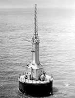
95. North Manitou Shoal Light ("The Crib")
- Location: Manitou Passage, Leelanau County, MI
- Coordinates: 45°01'48.0"N 85°51'12.0"W (45.0300, -85.8533)
- Status: Active.
- History: A 1935 offshore lighthouse on a crib, built to replace a lightship.
- Viewing Information: Not accessible. Can be seen distantly from the Sleeping Bear Dunes or on boat tours.
96. Old Mackinac Point Lighthouse
- Location: Straits of Mackinac. Mackinaw City, Cheboygan County, MI
- Coordinates: 45.7875°N 84.72944°W
- Status: Deactivated. Museum.
- History: An 1892 lighthouse designed to look like a castle. It was deactivated in 1957 after the Mackinac Bridge was completed, rendering the light obsolete.
- Viewing Information: Part of the Mackinac State Historic Parks system. The beautifully restored keeper's quarters and tower are open for tours with an admission fee.
97. Peninsula Point Light
- Location: Lake Michigan, Bay de Noc Township, Delta County, MI
- Coordinates: 45.6682°N 86.9666°W
- Status: Inactive
- History: 1856/1866
- Viewing Information: On private land but viewable from a distance.
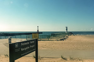 98. Pentwater North & South Pierhead Lights 98. Pentwater North & South Pierhead Lights
- Location: Pentwater, Oceana County, MI
- Coordinates: 43°46'30.0"N 86°26'42.0"W (43.7750, -86.4450)
- Status: Active.
- History: The current 1937 skeletal towers are located on either end of the pier.
- Viewing Information: Accessible by walking the pier from Charles Mears State Park.
99. Petoskey Pierhead Light
- Location: Petoskey, Emmet County, MI
- Coordinates: 45°22'48.0"N 84°57'54.0"W (45.3800, -84.9650)
- Status: Active.
- History: The current 1930 steel tower sits on the breakwater.
- Viewing Information: Accessible by walking the breakwater.
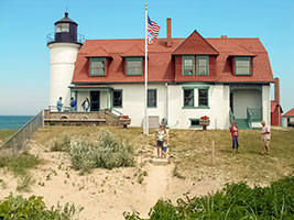 100. Point Betsie Lighthouse 100. Point Betsie Lighthouse
- Location: Frankfort, Benzie County, MI
- Coordinates: 44°41'28.0"N 86°15'32.0"W (44.6911, -86.2589)
- Status: Active.
- History: An 1858 brick tower, this was the last manned lighthouse on Lake Michigan. It marked the southern entrance to the Manitou Passage.
- Viewing Information: The grounds, museum, and tower are open for tours on a seasonal schedule.
101. Poverty Island Light
- Location: Lake Michigan, Entrance to Green Bay, Poverty Island, MI
- Coordinates: 45.52722°N 86.66361°W
- Status: Active
- History: Built in 1874
- Viewing Information: Viewable by boat only
102. Sand Point Light
- Location: Lake Michigan, Escanaba, Delta County, MI
- Coordinates: 45.74444°N 87.04444°W
- Status: Inactive, part of museum
- History: Built in 1867
- Viewing Information: Privately owned museum, accessible to guests
 103. Seul Choix Light 103. Seul Choix Light
- Location: Lake Michigan, Mueller Township, Schoolcraft County, MI
- Coordinates: 45.92139°N 85.91194°W
- Status: Active
- History: Built in 1892
- Viewing Information: Viewable from park of the same name
 104. South Fox Island Light 104. South Fox Island Light
- Location: South Fox Island, Leelanau County, MI
- Coordinates: 45°25'30.0"N 85°50'42.0"W (45.4250, -85.8450)
- Status: Deactivated.
- History: An 1867 brick lighthouse on a remote island. A preservation society is working to restore the abandoned station.
- Viewing Information: The island is very remote and only accessible by private boat or on special tours.
105. South Haven South Pierhead Light
- Location: South Haven, Van Buren County, MI
- Coordinates: 42°24'00.0"N 86°17'42.0"W (42.4000, -86.2950)
- Status: Active.
- History: The current 1903 red, cylindrical cast-iron tower at the end of a pier is a classic symbol of this Lake Michigan beach town.
- Viewing Information: The lighthouse can be reached by walking the pier from South Beach.
 106. South Manitou Island Lighthouse 106. South Manitou Island Lighthouse
- Location: South Manitou Island, Leelanau County, MI
- Coordinates: 45°00'36.0"N 86°05'36.0"W (45.0100, -86.0933)
- Status: Deactivated.
- History: The current 100-foot brick tower was built in 1871. It was a vital light for ships seeking refuge in the island's harbor. It was deactivated in 1958.
- Viewing Information: Located in the Sleeping Bear Dunes National Lakeshore. The island is accessible by public ferry. The tower is open for climbs led by park rangers.
107. Squaw (Ojibwa) Island Light
- Location: Lake Michigan, Squaw Island, St. James Township, Charleveaux County, MI
- Coordinates: 45.8399°N 85.58713°W
- Status: Inactive
- History: Built in 1892
- Viewing Information: Privately owned, viewable from boat
 108. St. Helena Island Light 108. St. Helena Island Light
- Location: Straits of Mackinac, Mackinac County, MI
- Coordinates:45.855°N 84.86333°W
- Status: Active.
- History: An 1873 brick tower connected to the keeper's house. After being abandoned, it was beautifully restored by the Great Lakes Lighthouse Keepers Association.
- Viewing Information: The island is not easily accessible. It can be seen by boat or on special tours.
109. St. Joseph North Pier Inner & Outer Lights
- Location: Tiscornia Park, St. Joseph, Berrien County, MI
- Coordinates: 42°06'52.0"N 86°29'54.0"W (42.1144, -86.4983)
- Status: Active.
- History: An iconic pair of 1907 pierhead lights connected by a catwalk, guiding ships into the St. Joseph River from Lake Michigan.
- Viewing Information: Easily accessible by walking the north pier from Tiscornia Park.
.jpg) 110. Wawatam Lighthouse 110. Wawatam Lighthouse
- Location: Lake Michigan, St. Ignace Harbor, Emmet County, MI
- Coordinates: 45°51′57″N 84°42′55″W
- Status: Active
- History: Built in 2006, originally meant for decorative purposes only then converted to an automated navigatiinal device upon completion of light.
- Viewing Information: Viewable from pier and waterfront
 111. Waugoshance Light 111. Waugoshance Light
- Location: Straits of Mackinac, Emmet County, MI
- Coordinates: 45°47'12.0"N 85°08'06.0"W (45.7867, -85.1350)
- Status: Deactivated. In ruins.
- History: An 1851 brick and iron-plated lighthouse built on a crib in a very dangerous shoal area. It was the first "offshore" lighthouse built on the Great Lakes. It was used for bombing practice during WWII and now stands as a ruin.
- Viewing Information: Not accessible and is a ruin. It can only be seen on specialized lighthouse cruises.
 112. White River Light 112. White River Light
- Location: Whitehall, Muskegon County, MI
- Coordinates: 43°22'42.0"N 86°20'42.0"W (43.3783, -86.3450)
- Status: Deactivated. Museum.
- History: An 1875 octagonal brick tower connected to the keeper's house. It was deactivated in 1960.
- Viewing Information: The lighthouse and museum are open for tours and climbs seasonally.
 113. White Shoal Light 113. White Shoal Light
- Location: Straits of Mackinac, Emmet County, MI
- Coordinates: 45°50'30.0"N 85°08'06.0"W (45.8417, -85.1350)
- Status: Active. Privately owned.
- History: A massive 1910 offshore lighthouse known for its distinctive red and white "barber pole" stripes. It is considered a masterpiece of engineering.
- Viewing Information: Not accessible. It is located 20 miles west of the Mackinac Bridge and can only be seen on specialized lighthouse cruises.
[ Back to Top ]
Michigan's Upper Peninsula, South Shore
Lake Michegan
 114. Fayette Lighthouse (Poverty Island Transfer) 114. Fayette Lighthouse (Poverty Island Transfer)
- Location: Snail Shell Harbor, Fayette Historic State Park, Delta County, MI
- Coordinates: 45°43'09.8"N 86°39'57.4"W (45.7194, -86.6659)
- Status: Display.
- History: This is not a traditional lighthouse but the lantern room from the 1886 Poverty Island Lighthouse. The lantern room was removed by helicopter in 1988 and is now displayed on a concrete base at the entrance to Snail Shell Harbor.
- Viewing Information: The lantern room is fully accessible for viewing within the Fayette Historic State Park.
115. Lansing Shoal Light
- Location: Lake Michigan, off the southern coast of the Upper Peninsula, MI
- Coordinates: 45°34'00.0"N 86°59'00.0"W (45.5667, -86.9833)
- Status: Active.
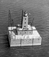
- History: A massive concrete and steel lighthouse built on a crib in 1928 to replace a lightship. It was one of the most expensive and modern lighthouses built on the Great Lakes at the time. It was automated in 1976.
- Viewing Information: Not accessible. It is located 11 miles offshore and can only be seen by private boat or on specialized lighthouse cruises.
116. Manistique East Breakwater Light
- Location: Manistique, Schoolcraft County, MI
- Coordinates: 45°56'38.0"N 86°14'45.0"W (45.9439, -86.2458)
- Status: Active.
- History: A 1916 bright red, square pyramidal tower on a breakwater in Manistique's harbor.
- Viewing Information: The lighthouse is easily viewed and photographed from the public boardwalk and park along the harbor.
117. Minneapolis Shoal Light
- Location: Lake Michigan, south of the Garden Peninsula, MI
- Coordinates: 45°32'00.0"N 86°43'00.0"W (45.5333, -86.7167)
- Status: Active.
- History: A 1935 offshore lighthouse built on a concrete pier. It was automated in 1979.
- Viewing Information: Not accessible. It is located in the open waters of Lake Michigan and can only be seen by private boat.
118. Peninsula Point Lighthouse
- Location: Stonington Peninsula, Delta County, MI
- Coordinates: 45°40'35.0"N 86°57'55.0"W (45.6764, -86.9653)
- Status: Deactivated. In ruins.
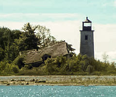
- History: An 1865 brick lighthouse built to guide ships into Green Bay. It was deactivated in 1937, replaced by the Minneapolis Shoal Light. A fire in 1959 destroyed the keeper's house, leaving only the brick tower standing.
- Viewing Information: Located in the Hiawatha National Forest. The grounds are open, and visitors can climb an iron spiral staircase inside the ruined tower for panoramic views of Lake Michigan.
119. Poverty Island Lighthouse
- Location: Poverty Island, Delta County, MI
- Coordinates: 45°35'40.0"N 86°37'05.0"W (45.5944, -86.6181)
- Status: Deactivated. In ruins.
- History: An 1875 brick tower built on a remote and rugged island. After automation, the station was abandoned and fell into severe disrepair, with vandals doing significant damage. The lantern room was removed in 1988 and is now displayed at the Fayette Historic State Park.
- Viewing Information: The island is extremely remote, difficult to access, and the structure is in a dangerous state of ruin. It is not recommended for visitation.
120. Sand Point Lighthouse (Escanaba)
- Location: Escanaba, Delta County, MI
- Coordinates: 45°44'23.0"N 87°02'30.0"W (45.7397, -87.0417)
- Status: Deactivated. Museum.
- History: An 1868 brick lighthouse that now houses the lantern and lens from the Poverty Island Lighthouse.
- Viewing Information: Located in Ludington Park. The tower and keeper's house are open for tours seasonally.
121. Seul Choix Point Lighthouse
- Location: Gulliver, Schoolcraft County, MI
- Coordinates: 45°55'18.0"N 86°00'49.0"W (45.9217, -86.0136)
- Status: Active. Museum.
- History: An 1895 brick tower with an attached keeper's house on Lake Michigan's north shore. The name is French for "only choice," referring to its harbor as the only refuge in the area. It is said to be haunted.
- Viewing Information: The grounds, museum, and tower are open to the public seasonally for a fee.
[ Back to Top ]
Michigan's Upper Peninsula, North Shore
Lake Superior
Michigan (Upper Peninsula)
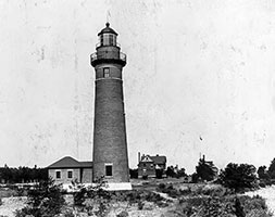
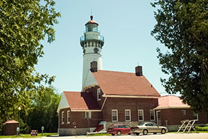
122. Au Sable Light Station
- Location: Pictured Rocks National Lakeshore, Alger County, MI
- Coordinates: 46°40'25.0"N 86°08'26.0"W (46.6736, -86.1406)
- Status: Deactivated. Museum.
- History: An 1874 brick tower, this 86-foot lighthouse marks the dangerous Au Sable Point, which was a notorious "ship trap." The station has been beautifully restored by the National Park Service.
- Viewing Information: Located within Pictured Rocks National Lakeshore. Access requires a 1.5-mile walk from the Hurricane River Campground. The grounds are open, and ranger-led tours of the tower are offered seasonally.
 123. Big Bay Point Lighthouse 123. Big Bay Point Lighthouse
- Location: Big Bay, Marquette County, MI
- Coordinates: 46°50'40.0"N 87°41'13.0"W (46.8444, -87.6869)
- Status: Active (Private Aid). Operates as a Bed & Breakfast.
- History: An 1896 duplex-style brick lighthouse with a square tower. It is perched on a high cliff and is one of the few lighthouses in the country that operates as a B&B. It is said to be haunted by its first keeper.
- Viewing Information: The grounds are open to the public during the day. The tower is open only to overnight guests of the inn.
124. Copper Harbor Front Range Light
- Location: Big Bay
- Coordinates: 46.67306°N 86.13933°W
- Status: Active
- History: ?
- Viewing Information:
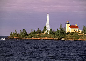 125. Copper Harbor Lighthouse 125. Copper Harbor Lighthouse
- Location: Copper Harbor, Keweenaw County, MI
- Coordinates: 47°28'32.0"N 87°51'33.0"W (47.4756, -87.8592)
- Status: Deactivated. Museum.
- History: The current 1866 lighthouse, with a steel tower attached to the keeper's house, is part of the Keweenaw National Historical Park system. It guarded the entrance to the vital copper shipping port.
- Viewing Information: Located in a state park. The lighthouse can be viewed by taking the Copper Harbor Lighthouse Tour boat, which includes a tour of the grounds and keeper's house.
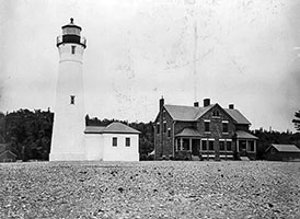 126. Crisp Point Lighthouse 126. Crisp Point Lighthouse
- Location: Near Newberry, Luce County, MI
- Coordinates: 46°45'40.0"N 85°20'28.0"W (46.7611, -85.3411)
- Status: Active (Private Aid).
- History: An 1876 lifesaving station that had a light added in 1904. The 58-foot brick tower stands in a very remote location. After being deactivated, it was saved from collapse by the Crisp Point Light Historical Society, who have beautifully restored it and the grounds.
- Viewing Information: Located at the end of a long, unpaved road. Access can be difficult, but the grounds are open to the public, and the tower is open for climbs when volunteers are present.
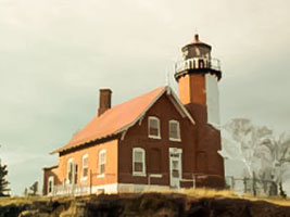 127. Eagle Harbor Lighthouse 127. Eagle Harbor Lighthouse
- Location: Eagle Harbor, Keweenaw County, MI
- Coordinates: 47°27'37.0"N 88°09'38.0"W (47.4603, -88.1606)
- Status: Active.
- History: An 1871 octagonal brick tower attached to a keeper's house. The station now includes several museum buildings managed by the Keweenaw County Historical Society.
- Viewing Information: The grounds and museums are open seasonally. Tower tours are often available.
128. Eagle Harbor Rear Range Lights
- Location: Eagle Harbor, Keweenaw County, MI
- Coordinates: 47°27'22.0"N 88°09'24.0"W (47.4561, -88.1567)
- Status: Deactivated.
- History: A 1908 skeletal tower that was deactivated in 2011.
- Viewing Information: The tower stands in a residential area and can be viewed from the street.
 129. Eagle River Lighthouse 129. Eagle River Lighthouse
- Location: Eagle River, Keweenaw County, MI
- Coordinates: 47°24'46.0"N 88°17'41.0"W (47.4128, -88.2947)
- Status: Deactivated. Privately owned.
- History: An 1858 lighthouse that is now a private residence and part of the Keweenaw Heritage Trail.
- Viewing Information: Private property. It can be viewed from the nearby beach.
130. Fourteen Mile Point Light
- Location: Ontonagon
- Coordinates: 46.99285°N 89.12573°W
- Status:Active
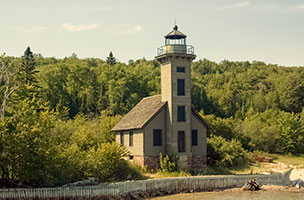 131. Grand Island East Channel Light 131. Grand Island East Channel Light
- Location: Grand Island, Munising, Alger County, MI
- Coordinates: 46°27'43.0"N 86°38'06.0"W (46.4619, -86.6350)
- Status: Deactivated. Privately owned.
- History: A beautiful 1868 wooden lighthouse built to guide ships into Munising Harbor. It was deactivated in 1913. After falling into disrepair, it has been beautifully restored by its private owners.
- Viewing Information: Private property. It can only be viewed by boat on Pictured Rocks cruises.
132. Grand Island Harbor Rear Range Light
- Location: Christmas
- Coordinates:46.43667°N 86.69111°W
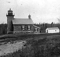 133. Grand Island North Light 133. Grand Island North Light
- Location: Grand Island, Munising, Alger County, MI
- Coordinates: 46°33'36.0"N 86°39'21.0"W (46.5600, -86.6558)
- Status: Deactivated. Privately owned.
- History: An 1867 brick lighthouse perched dramatically on a 175-foot cliff. It was deactivated in 1961.
- Viewing Information: Private property and not accessible. It can only be viewed by boat tours.
134. 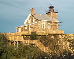 Granite Island Light Granite Island Light
- Location: Granite Island, near Marquette, Marquette County, MI
- Coordinates: 46°43'20.0"N 87°25'00.0"W (46.7222, -87.4167)
- Status: Active (Private Aid).
- History: An 1869 stone lighthouse built on a barren granite island. It was sold to a private owner who has meticulously restored it.
- Viewing Information: Private property and not accessible. Can be seen distantly from the mainland or on boat tours.
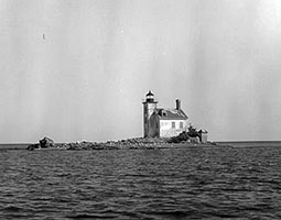 135. Gull Rock Light Station 135. Gull Rock Light Station
- Location: Manitou Passage, Keweenaw County, MI
- Coordinates: 47°24'42.0"N 87°41'36.0"W (47.4117, -87.6933)
- Status: Active.
- History: An 1867 brick lighthouse on a small, dangerous reef.
- Viewing Information: Not accessible. Best viewed by boat.
.jpg) 136. Huron Island Lighthouse 136. Huron Island Lighthouse
- Location: Huron Islands, Marquette County, MI
- Coordinates: 46°57'48.0"N 88°00'24.0"W (46.9633, -88.0067)
- Status: Active.
- History: An 1868 granite lighthouse on a remote island group.
- Viewing Information: The islands are a National Wildlife Refuge and access is difficult. Best viewed by boat.
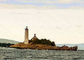 137. Isle Royale Lighthouse 137. Isle Royale Lighthouse
- Location: Isle Royale National Park, Keweenaw County, MI
- Coordinates: 47°55'48.0"N 88°45'42.0"W (47.9300, -88.7617)
- Status: Deactivated.
- History: An 1875 octagonal brick and stone lighthouse built on a small island to guide ships into the Siskiwit Bay.
- Viewing Information: Located in Isle Royale National Park and is only accessible by private boat or on certain park tours.
138. Jacobsville Lighthouse (Portage River)
- Location: Jacobsville, Houghton County, MI
- Coordinates: 47°01'44.0"N 88°25'48.0"W (47.0289, -88.4300)
- Status: Deactivated. Privately owned.
- History: An 1869 lighthouse built in the "schoolhouse" style. It is now a private residence and Bed & Breakfast.
- Viewing Information: Private property, open only to guests. Can be viewed from the water.
139. Keweenaw Waterway Lower Entrance Light
- Location: Jacobsville
- Coordinates: 46.96879°N 88.4311°W
140. Keweenaw Waterway Upper Entrance Light
- Location: McLain State Park, Houghton County, MI
- Coordinates: 47°14'42.0"N 88°37'36.0"W (47.2450, -88.6267)
- Status: Active.
- History: A 1950 lighthouse at the end of a breakwater. It is a well-known local landmark.
- Viewing Information: Accessible by walking the breakwater from McLain State Park.
141. Manitou Island Light
- Location: Manitou Island
- Coordinates:47.41972°N 87.58722°W
142. Marquette Breakwater Outer Light
- Location: Marquette
- Coordinates: 46.5338°N 87.37473°W
143. Marquette Harbor Lighthouse
- Location: Marquette, Marquette County, MI
- Coordinates: 46°32'53.0"N 87°22'25.0"W (46.5481, -87.3736)
- Status: Active.
- History: The current 1866 iron tower, painted a vibrant red, is one of the most iconic sights in Marquette.
- Viewing Information: The Marquette Maritime Museum offers tours of the lighthouse, which is on an active Coast Guard station. It can also be viewed from McCarty's Cove beach.
144. Mendota (Bete Grise) Light
- Location: Delaware. Grant Township, Keweenaw County, MI
- Coordinates: 47°23'24.0"N 88°00'00.0"W (47.3900, -88.0000)
- Status: Active (Private Aid).
- History: An 1895 brick lighthouse that was deactivated and sold, but later relit as a private aid.
- Viewing Information: Private property. It can be viewed from the road at the Mendota Ship Canal.
145. Munising Rear Range Light
- Location: Munising
- Coordinates:46.41254°N 86.66396°W
146. Ontonagon Harbor West Breakwater Light
- Location: Ontonagon
- Coordinates: 46.87947°N 89.33084°W
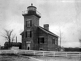 147. Ontonagon Lighthouse 147. Ontonagon Lighthouse
- Location: Ontonagon, Ontonagon County, MI
- Coordinates: 46°52'32.0"N 89°19'16.0"W (46.8756, -89.3211)
- Status: Deactivated. Museum.
- History: A cream-colored 1866 brick lighthouse that guided ships into the Ontonagon River, a key port during the copper boom.
- Viewing Information: The Ontonagon County Historical Society offers tours of the lighthouse seasonally.
148. Passage Island Light
- Location: Ontonagon
- Coordinates: 46.87947°N 89.33084°W
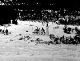 149. Point Iroquois Lighthouse 149. Point Iroquois Lighthouse
- Location: Hiawatha National Forest, Chippewa County, MI
- Coordinates: 46°29'08.0"N 84°37'56.0"W (46.4856, -84.6322)
- Status: Deactivated. Museum.
- History: The current 1870 brick tower overlooks the entrance to the St. Marys River from Lake Superior, a point where many ships have wrecked. The station is now a museum.
- Viewing Information: Located in the Hiawatha National Forest. The museum and tower are open to the public seasonally.
150. Portage Lake Lower Entrance Light
- Location: Keweenaw Waterway, Houghton County, MI
- Coordinates: 47°07'20.0"N 88°27'56.0"W (47.1222, -88.4656)
- Status: Active.
- History: A 1902 octagonal tower that served as a rear range light. It now stands as a single light.
- Viewing Information: Can be viewed from the water or distantly from the road.
151. Presque Isle Harbor Breakwater Light
- Location: Marquette, Marquette County, MI
- Coordinates:46.574144°N 87.374577°W
- Status: Active.
- History: A 1941 concrete lighthouse at the end of the breakwater for Marquette's upper harbor.
- Viewing Information: Accessible by walking the breakwater from Presque Isle Park.
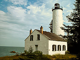 152. Rock Harbor Lighthouse 152. Rock Harbor Lighthouse
- Location: Isle Royale National Park, Keweenaw County, MI
- Coordinates: 48°05'40.0"N 88°31'24.0"W (48.0944, -88.5233)
- Status: Deactivated.
- History: An 1855 brick tower, this was the first lighthouse built on Isle Royale. It was only active for a few years before being abandoned.
- Viewing Information: Located in Isle Royale National Park. It can be reached by hiking trails from the Rock Harbor area.
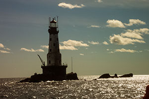 153. Rock of Ages Lighthouse 153. Rock of Ages Lighthouse
- Location: Isle Royale National Park, Washington Island (Offshore), Keweenaw County, MI
- Coordinates: 47.86667°N 89.31333°W
- Status: Active.
- History: A 1908 steel-framed, brick-lined tower built on a remote and dangerous reef off the coast of Isle Royale. It is considered one of the most magnificent and well-engineered lighthouses on the Great Lakes.
- Viewing Information: Not accessible. It can only be viewed by boat on special sightseeing tours within the national park.
154. Sand Hills Lighthouse
- Location: Ahmeek, Keweenaw County, MI
- Coordinates:47.39194°N 88.37042°W
- Status: Active (Private Aid). Operates as an inn.
- History: Built in 1917, this was the last and most modern manned lighthouse built on the Great Lakes. The massive brick structure now operates as a private inn.
- Viewing Information: The lighthouse is a private inn, open only to guests.
155. Sand Point Light (Baraga)
- Location: Baraga
- Coordinates:46.78337°N 88.46685°W
- Status:
- History:
- Viewing Information:
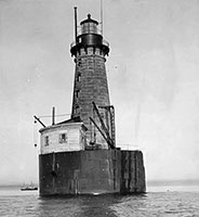 156. Stannard Rock Light 156. Stannard Rock Light
- Location: Lake Superior, off Marquette, MI
- Coordinates: 47°10'55.0"N 87°13'32.0"W (47.1819, -87.2256)
- Status: Active.
- History: Known as the "Loneliest Place in the World," this 1882 lighthouse is the most distant from shore of any U.S. lighthouse (24 miles from the nearest land). Its construction on a remote reef was a monumental engineering feat.
- Viewing Information: Not accessible. It can only be reached by private boat on a long and often rough journey.
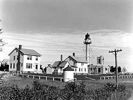 157. Whitefish Point Lighthouse 157. Whitefish Point Lighthouse
- Location: Whitefish Point, Chippewa County, MI
- Coordinates: 46°46'18.0"N 84°57'21.0"W (46.7717, -84.9558)
- Status: Active.
- History: The oldest active light on Lake Superior, this 1861 skeletal tower marks a critical turning point in the "Graveyard of the Great Lakes." It is the site of the Great Lakes Shipwreck Museum, which commemorates the wreck of the Edmund Fitzgerald and many others.
- Viewing Information: The grounds and museum are open to the public with an admission fee. The lighthouse is part of the museum complex.
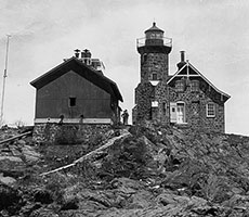 158. Passage Island Light 158. Passage Island Light
- Location: Passage Island, Isle Royale National Park, MI
- Coordinates: 48°13'32.0"N 88°21'54.0"W (48.2256, -88.3650)
- Status: Active.
- History: An 1882 stone lighthouse with an integrated tower, it marks the primary shipping channel for vessels entering Isle Royale's northern harbors from Thunder Bay. It is a very remote and significant station on Lake Superior.
- Viewing Information: Located in a remote part of Isle Royale National Park. The lighthouse is not open to the public, but it is a common and welcome sight for tour boats and ferries that service the northeast end of the park.
[ Back to Top ]
Indiana (4)
Lake Michigan
1. Buffington Harbor Breakwater Light
- Location: Gary, Lake County, IN
- Coordinates: 41°38'22.0"N 87°24'25.0"W (41.6394, -87.4069)
- Status: Active.
- History: A 1926 steel tower built to serve the industrial harbor.
- Viewing Information: Located in an industrial area and is not easily accessible for public viewing.
2. Indiana Harbor East Breakwater Light
- Location: East Chicago, Lake County, IN
- Coordinates: 41°40'30.0"N 87°27'30.0"W (41.6750, -87.4583)
- Status: Active.
- History: A 1935 Art Deco-style concrete lighthouse.
- Viewing Information: Located on a breakwater in an industrial area and is not accessible. Best viewed by boat.
3. Michigan City East Pierhead Light
- Location: Michigan City, LaPorte County, IN
- Coordinates: 41°43'36.0"N 86°54'32.0"W (41.7267, -86.9089)
- Status: Active.
- History: The current 1904 cast-iron tower sits at the end of a pier and is connected to the shore by an elevated catwalk, the only one of its kind remaining in Indiana.
- Viewing Information: Accessible by walking the pier from Washington Park.
4. Michigan City Lighthouse
- Location: Michigan City, LaPorte County, IN
- Coordinates: 41°43'21.0"N 86°54'08.0"W (41.7225, -86.9022)
- Status: Deactivated. Museum.
- History: The 1858 lighthouse was remodeled in 1904, when the lantern room was removed and placed on the new pierhead light. The building now serves as a local history museum.
- Viewing Information: The lighthouse museum is located in Washington Park and is open to the public.
Illinois (3)
Lake Michigan
1. Chicago Harbor Lighthouse
- Location: Chicago, Cook County, IL
- Coordinates: 41°53'20.0"N 87°35'27.0"W (41.8889, -87.5908)
- Status: Active.
- History: The current 1893 conical tower was originally built for the World's Columbian Exposition and was moved to its present location on a breakwater in 1919.
- Viewing Information: Not accessible. It can be viewed well from Navy Pier, from boat tours, and from the Adler Planetarium.
2. Grosse Point Lighthouse
- Location: Evanston, Cook County, IL
- Coordinates: 42°03'31.0"N 87°40'28.0"W (42.0586, -87.6744)
- Status: Active (Private Aid). National Historic Landmark.
- History: An 1873 brick tower built to guide ships into Chicago after the Great Chicago Fire. It was deactivated in 1941 but was relit as a private aid in 1945.
- Viewing Information: The lighthouse is located in a public park. The grounds are open, and the tower is open for climbs on weekends during the summer.
3. Waukegan Harbor Light
- Location: Waukegan, Lake County, IL
- Coordinates: 42°21'35.0"N 87°48'09.0"W (42.3597, -87.8025)
- Status: Active.
- History: A 1967 cylindrical tower at the end of a pier. It replaced an earlier 1889 lighthouse.
- Viewing Information: Accessible by walking the pier.
Wisconsin (25)
Lake Michigan
1. Algoma Pierhead Light
- Location: Algoma, Kewaunee County, WI
- Coordinates: 44°36'28.0"N 87°25'39.0"W (44.6078, -87.4275)
- Status: Active.
- History: The current 1932 red steel tower sits at the end of the north pier, replacing an 1893 wooden structure.
- Viewing Information: Accessible by walking the pier.
2. Baileys Harbor Range Lights
- Location: Baileys Harbor, Door County, WI
- Coordinates: 45°04'09.0"N 87°07'44.0"W (45.0692, -87.1289)
- Status: Deactivated.
- History: A pair of 1869 range lights that worked in tandem to guide ships into Baileys Harbor. They were replaced by the Cana Island Light in 1929.
- Viewing Information: The lights are located on the grounds of The Ridges Sanctuary and are accessible via hiking trails.
3. Cana Island Lighthouse
- Location: Baileys Harbor, Door County, WI
- Coordinates: 45°05'21.0"N 87°03'07.0"W (45.0892, -87.0519)
- Status: Active.
- History: An iconic 1869 brick tower on a small island. It is one of the most popular and photographed lighthouses in Wisconsin.
- Viewing Information: The lighthouse and museum are open for tours. Access requires crossing a stone causeway from the mainland that can be submerged in high water.
4. Chambers Island Lighthouse
- Location: Chambers Island, Door County, WI
- Coordinates: 45°11'36.0"N 87°21'39.0"W (45.1933, -87.3608)
- Status: Deactivated.
- History: An 1868 lighthouse built in the "schoolhouse" style. It was deactivated in 1961. The town of Gibraltar is working to restore it.
- Viewing Information: The island is accessible by private boat. The lighthouse is a short hike from the town dock.
5. Kenosha Light (Southport)
- Location: Kenosha, Kenosha County, WI
- Coordinates: 42°35'14.0"N 87°48'30.0"W (42.5872, -87.8083)
- Status: Deactivated. Museum.
- History: An 1866 brick tower that was deactivated in 1906 when the pierhead light was improved. The station is now a museum.
- Viewing Information: The keeper's house is a museum, and the lighthouse is open for climbs on weekends during the summer.
6. Kewaunee Pierhead Light
- Location: Kewaunee, Kewaunee County, WI
- Coordinates: 44°27'31.0"N 87°29'38.0"W (44.4586, -87.4939)
- Status: Active.
- History: The current 1912 tower sits at the end of the north pier. It is a well-preserved example of a pierhead light station.
- Viewing Information: Accessible by walking the pier.
7. North Point Lighthouse
- Location: Milwaukee, Milwaukee County, WI
- Coordinates: 43°04'02.0"N 87°52'47.0"W (43.0672, -87.8797)
- Status: Deactivated. Museum.
- History: The current 1888 octagonal tower was built on a bluff in Lake Park. It was raised to its current 74-foot height in 1912. It was deactivated in 1994.
- Viewing Information: The beautifully restored lighthouse and keeper's quarters are open as a museum with regular tour hours.
8. Pilot Island Lighthouse
- Location: Pilot Island, Door County, WI
- Coordinates: 45°17'15.0"N 86°55'13.0"W (45.2875, -86.9203)
- Status: Deactivated.
- History: An 1858 lighthouse built to mark the treacherous Porte des Morts ("Death's Door") passage. It was known as one of the most difficult and unpleasant stations due to its isolation and fog.
- Viewing Information: The island is a wildlife refuge and is not open to the public. It can be seen on some boat tours.
9. Port Washington Breakwater Light
- Location: Port Washington, Ozaukee County, WI
- Coordinates: 43°23'11.0"N 87°51'48.0"W (43.3864, -87.8633)
- Status: Active.
- History: A 1935 Art Deco-style pierhead light. It is a beloved local landmark.
- Viewing Information: Accessible by walking the breakwater.
10. Pottawatomie Lighthouse (Rock Island)
- Location: Rock Island State Park, Door County, WI
- Coordinates: 45°25'00.0"N 86°48'37.0"W (45.4167, -86.8103)
- Status: Deactivated. Museum.
- History: The 1858 stone lighthouse is the oldest in Wisconsin. It was deactivated in 1988 but is maintained as a museum.
- Viewing Information: Located in a state park accessible only by ferry. The lighthouse is open for tours led by volunteer docents in the summer.
11. Sheboygan Breakwater Light
- Location: Sheboygan, Sheboygan County, WI
- Coordinates: 43°44'51.0"N 87°41'21.0"W (43.7475, -87.6892)
- Status: Active.
- History: The current 1915 tower sits at the end of the north breakwater. It was one of the last pierhead lights to be automated, in 1968.
- Viewing Information: Accessible by walking the breakwater.
12. Sherwood Point Lighthouse
- Location: Sturgeon Bay, Door County, WI
- Coordinates: 44°54'33.0"N 87°29'08.0"W (44.9092, -87.4856)
- Status: Active.
- History: An 1883 brick lighthouse that was the last manned lighthouse on the Great Lakes until it was automated in 1983.
- Viewing Information: The grounds are generally not open to the public but are open for one weekend a year during the Door County Lighthouse Festival.
13. Sturgeon Bay Canal North Pierhead Light
- Location: Sturgeon Bay, Door County, WI
- Coordinates: 44°47'28.0"N 87°18'06.0"W (44.7911, -87.3017)
- Status: Active.
- History: A bright red 1903 steel tower at the very end of the north pier, marking the entrance to the Sturgeon Bay Ship Canal from Lake Michigan.
- Viewing Information: Accessible by walking the long pier. It offers excellent views of the main Sturgeon Bay Canal Light.
14. Sturgeon Bay Canal Light
- Location: Sturgeon Bay, Door County, WI
- Coordinates: 44°47'38.0"N 87°18'42.0"W (44.7939, -87.3117)
- Status: Active.
- History: An 1899 steel cylinder tower set within a larger skeletal framework. It serves as the main coastal light for the area.
- Viewing Information: Located on an active Coast Guard station and the grounds are not open to the public. It can be viewed well from the adjacent pier and beach.
15. Wind Point Lighthouse
- Location: Wind Point, Racine County, WI
- Coordinates: 42°47'08.0"N 87°45'44.0"W (42.7856, -87.7622)
- Status: Active.
- History: At 108 feet, this 1880 brick tower is one of the tallest and oldest active lighthouses on the Great Lakes.
- Viewing Information: Located in a public park. The grounds are open, and the tower is open for climbs on select days during the summer.
[ Back to Top ]
Wisconsin
Lake Superior
16. Apostle Islands Lighthouses (General)
- Location: Apostle Islands National Lakeshore, Ashland & Bayfield Counties, WI
- Coordinates: Varies by island.
- Status: Active/Deactivated.
- History: The Apostle Islands have the largest and most complete collection of historic lighthouses in the nation. This includes the lights on Michigan Island (1857 & 1929), Raspberry Island (1862), Outer Island (1874), Sand Island (1881), and Devils Island (1891).
- Viewing Information: The lighthouses are part of the Apostle Islands National Lakeshore. The islands are accessible by cruise boats, private boats, or sea kayak. The National Park Service offers tours and ranger programs at several of the light stations during the summer.
17. Ashland Harbor Breakwater Light
- Location: Ashland, Ashland County, WI
- Coordinates: 46°35'46.0"N 90°52'08.0"W (46.5961, -90.8689)
- Status: Active.
- History: A 1915 concrete tower on the breakwater.
- Viewing Information: Not accessible, but can be viewed well from the Ashland waterfront.
18. Devils Island Lighthouse
- Location: Apostle Islands National Lakeshore, WI
- Coordinates: 47°04'42.0"N 90°43'12.0"W (47.0783, -90.7200)
- Status: Active.
- History: An 1891 skeletal tower, it is the only Apostle Islands lighthouse with its original Fresnel lens. It marks the northernmost point of the islands.
- Viewing Information: Accessible on Apostle Islands cruises.
19. La Pointe Lighthouse
- Location: Madeline Island, Ashland County, WI
- Coordinates: 46°48'48.0"N 90°40'28.0"W (46.8133, -90.6744)
- Status: Deactivated.
- History: An 1896 skeletal tower.
- Viewing Information: Can be seen on Apostle Islands boat tours.
20. Michigan Island Lighthouse
- Location: Apostle Islands National Lakeshore, WI
- Coordinates: 46°52'12.0"N 90°29'42.0"W (46.8700, -90.4950)
- Status: Active.
- History: This island has two towers: a beautiful but short-lived 1857 stone tower and a tall 1929 skeletal tower that was moved from Pennsylvania.
- Viewing Information: Accessible on Apostle Islands cruises.
21. Outer Island Lighthouse
- Location: Apostle Islands National Lakeshore, WI
- Coordinates: 47°02'24.0"N 90°25'00.0"W (47.0400, -90.4167)
- Status: Active.
- History: An 1874 brick tower on the most remote of the Apostle Islands.
- Viewing Information: Accessible on Apostle Islands cruises.
22. Raspberry Island Lighthouse
- Location: Apostle Islands National Lakeshore, WI
- Coordinates: 46°59'12.0"N 90°47'18.0"W (46.9867, -90.7883)
- Status: Active.
- History: An 1862 lighthouse known as the "Showplace of the Apostle Islands" because of its beautiful restoration.
- Viewing Information: The most visited of the Apostle Islands lights, with regular tours offered by the NPS.
23. Sand Island Lighthouse
- Location: Apostle Islands National Lakeshore, WI
- Coordinates: 46°58'36.0"N 90°56'24.0"W (46.9767, -90.9400)
- Status: Active.
- History: An 1881 brownstone lighthouse known for its beautiful and unique architecture.
- Viewing Information: Accessible on Apostle Islands cruises.
24. Superior Entry Light
- Location: Superior, Douglas County, WI
- Coordinates: 46°42'31.0"N 92°00'34.0"W (46.7086, -92.0094)
- Status: Active.
- History: The current 1913 lighthouse is a massive concrete structure at the end of the breakwater marking the entrance to Superior Bay.
- Viewing Information: Not accessible, but can be viewed from Wisconsin Point.
25. Wisconsin Point Light
- Location: Superior, Douglas County, WI
- Coordinates: 46°42'13.0"N 92°01'44.0"W (46.7036, -92.0289)
- Status: Deactivated.
- History: A small lighthouse that served as the rear range light. It was replaced by the Superior Entry Light.
- Viewing Information: Located on Wisconsin Point.
Minnesota (8)
Lake Superior
1. Duluth Harbor North Pier Light
- Location: Duluth, St. Louis County, MN
- Coordinates: 46°46'45.0"N 92°05'12.0"W (46.7792, -92.0867)
- Status: Active.
- History: A 1901 cast-iron tower on the north pier of the Duluth Ship Canal. It works in tandem with the South Pier Light.
- Viewing Information: Fully accessible by walking the pier from Canal Park. A popular spot to watch large ships pass under the Aerial Lift Bridge.
2. Duluth Harbor South Breakwater Inner Light
- Location: Duluth, St. Louis County, MN
- Coordinates: 46°46'44.0"N 92°05'23.0"W (46.7789, -92.0897)
- Status: Active.
- History: The 1889 skeletal tower is the rear light for the Duluth Ship Canal range.
- Viewing Information: Located on the south breakwater, which is not easily accessible. It is best viewed from Canal Park or from the water.
3. Duluth Harbor South Breakwater Outer Light
- Location: Duluth, St. Louis County, MN
- Coordinates: 46°46'42.0"N 92°05'11.0"W (46.7783, -92.0864)
- Status: Active.
- History: A 1901 light that serves as the front range light with the inner light.
- Viewing Information: Not easily accessible. Best viewed from Canal Park.
4. Grand Marais Light
- Location: Grand Marais, Cook County, MN
- Coordinates: 47°44'42.0"N 90°20'00.0"W (47.7450, -90.3333)
- Status: Active.
- History: An 1885 skeletal tower on a breakwater in the scenic harbor of Grand Marais.
- Viewing Information: Accessible by walking the breakwater from the shore.
5. Minnesota Point Light
- Location: Duluth, St. Louis County, MN
- Coordinates: 46°41'52.0"N 92°01'52.0"W (46.6978, -92.0311)
- Status: Deactivated. In ruins.
- History: The first lighthouse in Minnesota, this 1858 brick tower was abandoned after the Duluth Ship Canal was created. Only the crumbling stone foundation remains today.
- Viewing Information: The ruins are at the end of Minnesota Point, requiring a long walk.
6. Split Rock Lighthouse
- Location: Split Rock Lighthouse State Park, Lake County, MN
- Coordinates: 47°12'00.0"N 91°22'01.0"W (47.2000, -91.3669)
- Status: Deactivated. Museum. National Historic Landmark.
- History: One of the most famous and picturesque lighthouses in the United States. The 1910 brick tower is perched dramatically on a 130-foot cliff. It was built in response to a number of massive shipwrecks during a 1905 storm. It was decommissioned in 1969.
- Viewing Information: The centerpiece of Split Rock Lighthouse State Park and a major Minnesota Historical Society site. The light station and visitor center are open daily for tours.
7. Two Harbors Light
- Location: Two Harbors, Lake County, MN
- Coordinates: 47°00'56.0"N 91°39'48.0"W (47.0156, -91.6633)
- Status: Active. Operates as a Bed & Breakfast.
- History: The 1892 brick tower and keeper's house is the oldest operating lighthouse in Minnesota. It was built to guide the massive iron ore freighters into the harbor.
- Viewing Information: The station is operated as the Lighthouse Bed & Breakfast. The grounds are open to the public, and the tower is open for climbs when guests are not in residence.
8. Two Harbors East Breakwater Light
- Location: Two Harbors, Lake County, MN
- Coordinates: 47°00'54.0"N 91°39'36.0"W (47.0150, -91.6600)
- Status: Active.
- History: A modern light on a skeletal tower on the breakwater.
- Viewing Information: Can be viewed from the shore near the main Two Harbors Light.
[ Back to Top ]
[ | A | B | C | MAP | ]
Songs Associated with Lighthouses & The Great Lakes Region:
The Following thumbnails link to each song or product's specific page. All song lyrics/products have been written/designed by Mark S. McKenzie/American Storyteller Music and The Lyrical Horizon and produced by Story Teller Books and Music or Loud Mouth Books and Music, Copyright 2025, All Rights Reserved:


|
|
